Cuchilla Chica geodata
Cuchilla Chica (Veracruz) is a populated place; located in Mexico in America/Mexico_City (GMT-6) time zone. With population of 597 people, there are 14400 cities with bigger population in this country. Compared to other cities in Mexico, 81% of cities are located further ↓South; 59.9% of cities are located further ←West and 77.3% of cities have higher elevation than Cuchilla Chica. Note1


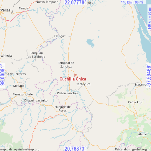
Cuchilla Chica GPS coordinates[2]
21° 25' 28.992" North, 98° 17' 52.008" West
| Map corner | latitude | longitude |
|---|---|---|
| Upper-left | 22.07778°, | -99.00091° |
| Center: | 21.42472°, | -98.29778° |
| Lower-right: | 20.76873°, | -97.59466° |
| Map W x H: | 145.6×145.6 km | = 90.5×90.5mi |
| max Lat: | 32.7° ⇑19% North |
| Cuchilla Chica: | 21.42472° |
| min Lat: | ⇓81% South 14.53588° |
| min Long | Cuchilla Chica | max Long |
| -117.105° | -98.29778° | -86.73105° |
| W 59.9%⇐ | ⇒40.1% E |
Elevation
Elevation of Cuchilla Chica is 146 m = 479 ft, and this is 1107.7 m = 3634 ft below average elevation for this country.
| Max E: |
3497 m = 11473 ft | 77.3% |
| Avg. | 1253.7 m = 4113 ft | |
| Cuchilla Chica | 146 m = 479 ft | |
Min E: |
-1 m = -3 ft | 22.7% |
See also: Mexico elevation on elevation.city.
Geographical zone
Cuchilla Chica is located in North Torrid zone (between Equator and Tropic of Cancer). Distance of this Northern Tropic circle is 223.7 km =139 mi to North.| Distance of | km | miles | from Cuchilla Chica |
|---|---|---|---|
| North Pole | 7624.9 | 4737.9 | to North |
| Arctic Circle | 5019 | 3118.7 | to North |
| Tropic Cancer | 223.7 | 139 | to North |
| Equator | 2382.2 | 1480.2 | to South |


Nearby cities:
15 places around Cuchilla Chica: (largest is in red/bold)
• Cerro Botica
3.6 km =2.2 mi,  114°
114°
• Ciruelar Aquiche
2.7 km =1.7 mi,  216°
216°
• El Jobo Aquiche
3.9 km =2.4 mi,  185°
185°
• El Rincón
1.8 km =1.1 mi,  345°
345°
• La Estanzuela
2 km =1.2 mi,  138°
138°
• La Peña
1.2 km =0.7 mi,  256°
256°
• Las Mesas San Gabriel (Las Mesas)
8.3 km =5.2 mi,  244°
244°
• Mezquite Mata del Tigre
7.5 km =4.7 mi, 106°
• Palma Alta
7.4 km =4.6 mi,  81°
81°
• Palmar Aquiche Primero
3.1 km =1.9 mi,  164°
164°
• Placetas
5.9 km =3.7 mi,  59°
59°
• Potrero Segundo
8.4 km =5.2 mi, 159°
• Rancho Nuevo
2.3 km =1.4 mi, 109°
• Terrero
4 km =2.5 mi,  28°
28°
• Trapiche
6.4 km =4 mi, 163°
Sources, notices
• [Note1] Compared only with cities in Mexico existing in our database
• [Src1] Map data: © OpenStreetMap contributors (CC-BY-SA)
• [Src2] Other city data from geonames.org with taken over terms of usage.
• [Src3] Geographical zone / Annual Mean Temperature by Robert A. Rohde @ Wikipedia
