Las Mesas San Gabriel (Las Mesas) geodata
Las Mesas San Gabriel (Las Mesas) (Veracruz) is a populated place; located in Mexico in America/Mexico_City (GMT-6) time zone. With population of 630 people, there are 13737 cities with bigger population in this country. Compared to other cities in Mexico, 80.8% of cities are located further ↓South; 59% of cities are located further ←West and 81.1% of cities have higher elevation than Las Mesas San Gabriel (Las Mesas). Note1
Current local time in Las Mesas San Gabriel (Las Mesas):
01:00 AM, WednesdayDifference from your time zone: hours


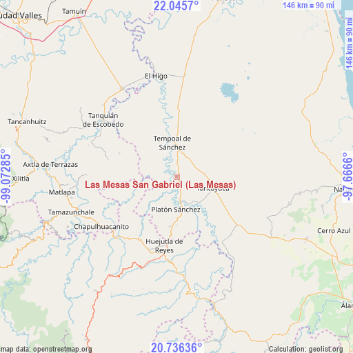
Las Mesas San Gabriel (Las Mesas) GPS coordinates[2]
21° 23' 33" North, 98° 22' 10.992" West
| Map corner | latitude | longitude |
|---|---|---|
| Upper-left | 22.0457°, | -99.07285° |
| Center: | 21.3925°, | -98.36972° |
| Lower-right: | 20.73636°, | -97.6666° |
| Map W x H: | 145.6×145.6 km | = 90.5×90.5mi |
| max Lat: | 32.7° ⇑19.2% North |
| Las Mesas San Gabriel (Las Mesas): | 21.3925° |
| min Lat: | ⇓80.8% South 14.53588° |
| min Long | Las Mesas San G | max Long |
| -117.105° | -98.36972° | -86.73105° |
| W 59%⇐ | ⇒41% E |
Elevation
Elevation of Las Mesas San Gabriel (Las Mesas) is 80 m = 262 ft, and this is 1173.7 m = 3851 ft below average elevation for this country.
| Max E: |
3497 m = 11473 ft | 81.1% |
| Avg. | 1253.7 m = 4113 ft | |
| Las Mesas San Gabriel (Las Mesas) | 80 m = 262 ft | |
Min E: |
-1 m = -3 ft | 18.9% |
See also: Mexico elevation on elevation.city.
Geographical zone
Las Mesas San Gabriel (Las Mesas) is located in North Torrid zone (between Equator and Tropic of Cancer). Distance of this Northern Tropic circle is 227.3 km =141.2 mi to North.| Distance of | km | miles | from Las Mesas San Gabriel (Las Mesas) |
|---|---|---|---|
| North Pole | 7628.4 | 4740.1 | to North |
| Arctic Circle | 5022.6 | 3120.9 | to North |
| Tropic Cancer | 227.3 | 141.2 | to North |
| Equator | 2378.6 | 1478 | to South |


Nearby cities:
15 places around Las Mesas San Gabriel (Las Mesas): (largest is in red/bold)
• Cerro Botica
11 km =6.8 mi,  79°
79°
• Ciruelar Aquiche
6 km =3.7 mi, 76°
• Cuchilla Chica
8.3 km =5.2 mi,  64°
64°
• El Aguacate Terrero
6.5 km =4 mi,  294°
294°
• El Jobo Aquiche
7.1 km =4.4 mi,  92°
92°
• El Remanso
10.3 km =6.4 mi,  169°
169°
• El Rincón
8.8 km =5.5 mi,  52°
52°
• La Estanzuela
9 km =5.6 mi, 76°
• La Peña
7.1 km =4.4 mi, 62°
• Palmar Aquiche Primero
8.3 km =5.2 mi, 86°
• Potrero Segundo
11.2 km =7 mi,  112°
112°
• Rancho Nuevo
10.1 km =6.3 mi,  73°
73°
• Terrero
11.8 km =7.3 mi, 52°
• Trapiche
9.6 km =6 mi, 105°
• Xiloxúchitl
11.4 km =7.1 mi,  116°
116°
Sources, notices
• [Note1] Compared only with cities in Mexico existing in our database
• [Src1] Map data: © OpenStreetMap contributors (CC-BY-SA)
• [Src2] Other city data from geonames.org with taken over terms of usage.
• [Src3] Geographical zone / Annual Mean Temperature by Robert A. Rohde @ Wikipedia
