Arenal geodata
Arenal (State of Mexico) is a populated place; located in Mexico in America/Mexico_City (GMT-6) time zone. With population of 6,700 people, there are 1400 cities with bigger population in this country. Compared to other cities in Mexico, 56.7% of cities are located further ↑North; 51.2% of cities are located further ←West and 84.8% of cities have lower elevation than Arenal. Note1


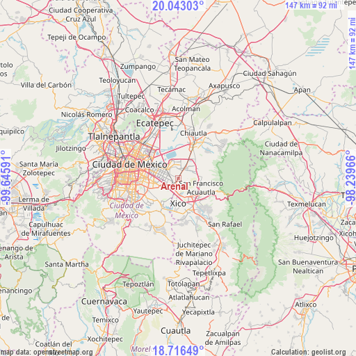
Arenal GPS coordinates[2]
19° 22' 51.996" North, 98° 56' 34.008" West
| Map corner | latitude | longitude |
|---|---|---|
| Upper-left | 20.04303°, | -99.64591° |
| Center: | 19.38111°, | -98.94278° |
| Lower-right: | 18.71649°, | -98.23966° |
| Map W x H: | 147.5×147.5 km | = 91.7×91.7mi |
| max Lat: | 32.7° ⇑56.7% North |
| Arenal: | 19.38111° |
| min Lat: | ⇓43.3% South 14.53588° |
| min Long | Arenal | max Long |
| -117.105° | -98.94278° | -86.73105° |
| W 51.2%⇐ | ⇒48.8% E |
Elevation
Elevation of Arenal is 2256 m = 7402 ft, and this is 1002.3 m = 3288 ft above average elevation for this country.
| Max E: |
3497 m = 11473 ft | 15.2% |
| Arenal | 2256 m 7402 ft | |
| Avg. | 1253.7 m = 4113 ft | |
Min E: |
-1 m = -3 ft | 84.8% |
See also: Mexico elevation on elevation.city.
Geographical zone
Arenal is located in North Torrid zone (between Equator and Tropic of Cancer). Distance of this Northern Tropic circle is 450.9 km =280.2 mi to North.| Distance of | km | miles | from Arenal |
|---|---|---|---|
| North Pole | 7852.1 | 4879.1 | to North |
| Arctic Circle | 5246.2 | 3259.8 | to North |
| Tropic Cancer | 450.9 | 280.2 | to North |
| Equator | 2155 | 1339.1 | to South |


Nearby cities:
15 places around Arenal: (largest is in red/bold)
• Ampliación 6 de Junio
5.2 km =3.2 mi,  160°
160°
• Bosques de la Magdalena
2.6 km =1.6 mi,  190°
190°
• El Pino
3.4 km =2.1 mi, 189°
• Lomas de Altavista
2.2 km =1.4 mi, 185°
• Lomas de San Sebastián
1 km =0.6 mi,  83°
83°
• Los Reyes Acaquilpan
4.1 km =2.5 mi,  241°
241°
• Magdalena Atlicpac
1.5 km =0.9 mi,  207°
207°
• Profesor Carlos Hank González
1.1 km =0.7 mi, 157°
• San Isidro
4.7 km =2.9 mi, 190°
• San José las Palmas
1.8 km =1.1 mi,  148°
148°
• San Sebastián Chimalpa
1.3 km =0.8 mi,  271°
271°
• Santa María Chimalhuacán
4.6 km =2.9 mi,  349°
349°
• Tecamachalco
2.9 km =1.8 mi,  216°
216°
• Techachaltitla
1.8 km =1.1 mi,  172°
172°
• Unidad Acaquilpan
1.6 km =1 mi, 166°
Sources, notices
• [Note1] Compared only with cities in Mexico existing in our database
• [Src1] Map data: © OpenStreetMap contributors (CC-BY-SA)
• [Src2] Other city data from geonames.org with taken over terms of usage.
• [Src3] Geographical zone / Annual Mean Temperature by Robert A. Rohde @ Wikipedia
