Lomas de San Sebastián geodata
Lomas de San Sebastián (State of Mexico) is a section of populated place; located in Mexico in America/Mexico_City (GMT-6) time zone. With population of 12,372 people, there are 785 cities with bigger population in this country. Compared to other cities in Mexico, 56.7% of cities are located further ↑North; 51.4% of cities are located further ←West and 86.9% of cities have lower elevation than Lomas de San Sebastián. Note1
Current local time in Lomas de San Sebastián:
02:49 AM, TuesdayDifference from your time zone: hours


Lomas de San Sebastián GPS coordinates[2]
19° 22' 55.416" North, 98° 55' 59.52" West
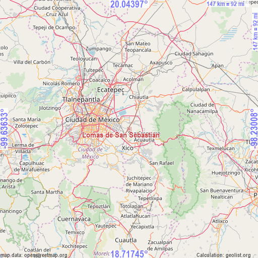
| Map corner | latitude | longitude |
|---|---|---|
| Upper-left | 20.04397°, | -99.63633° |
| Center: | 19.38206°, | -98.9332° |
| Lower-right: | 18.71745°, | -98.23008° |
| Map W x H: | 147.5×147.5 km | = 91.7×91.7mi |
| max Lat: | 32.7° ⇑56.7% North |
| Lomas de San Sebastián: | 19.38206° |
| min Lat: | ⇓43.3% South 14.53588° |
| min Long | Lomas de San Se | max Long |
| -117.105° | -98.9332° | -86.73105° |
| W 51.4%⇐ | ⇒48.6% E |
Elevation
Elevation of Lomas de San Sebastián is 2308 m = 7572 ft, and this is 1054.3 m = 3459 ft above average elevation for this country.
| Max E: |
3497 m = 11473 ft | 13.1% |
| Lomas de San Sebastián | 2308 m 7572 ft | |
| Avg. | 1253.7 m = 4113 ft | |
Min E: |
-1 m = -3 ft | 86.9% |
See also: Mexico elevation on elevation.city.
Geographical zone
Lomas de San Sebastián is located in North Torrid zone (between Equator and Tropic of Cancer). Distance of this Northern Tropic circle is 450.8 km =280.1 mi to North.| Distance of | km | miles | from Lomas de San Sebastián |
|---|---|---|---|
| North Pole | 7852 | 4879 | to North |
| Arctic Circle | 5246.1 | 3259.8 | to North |
| Tropic Cancer | 450.8 | 280.1 | to North |
| Equator | 2155.1 | 1339.1 | to South |


Nearby cities:
15 places around Lomas de San Sebastián: (largest is in red/bold)
• Arenal
1 km =0.6 mi,  263°
263°
• Bosques de la Magdalena
3.1 km =1.9 mi,  209°
209°
• Chicoloapan
5.1 km =3.2 mi,  40°
40°
• El Pino
3.8 km =2.4 mi,  204°
204°
• Lomas de Altavista
2.6 km =1.6 mi, 207°
• Los Reyes Acaquilpan
5 km =3.1 mi,  245°
245°
• Magdalena Atlicpac
2.2 km =1.4 mi,  229°
229°
• Profesor Carlos Hank González
1.2 km =0.7 mi, 208°
• San Isidro
5 km =3.1 mi, 201°
• San José las Palmas
1.6 km =1 mi,  181°
181°
• San Sebastián Chimalpa
2.3 km =1.4 mi,  268°
268°
• Santa María Chimalhuacán
4.7 km =2.9 mi,  337°
337°
• Tecamachalco
3.7 km =2.3 mi, 228°
• Techachaltitla
2 km =1.2 mi, 202°
• Unidad Acaquilpan
1.8 km =1.1 mi, 200°
Sources, notices
• [Note1] Compared only with cities in Mexico existing in our database
• [Src1] Map data: © OpenStreetMap contributors (CC-BY-SA)
• [Src2] Other city data from geonames.org with taken over terms of usage.
• [Src3] Geographical zone / Annual Mean Temperature by Robert A. Rohde @ Wikipedia
