La Arbolada Plus geodata
La Arbolada Plus (Jalisco) is a populated place; located in Mexico in America/Mexico_City (GMT-6) time zone. With population of 605 people, there are 14228 cities with bigger population in this country. Compared to other cities in Mexico, 68.6% of cities are located further ↓South; 87.6% of cities are located further →East and 52.7% of cities have lower elevation than La Arbolada Plus. Note1


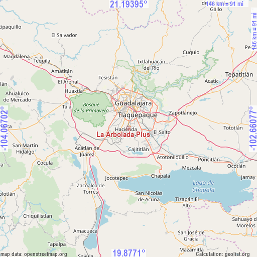
La Arbolada Plus GPS coordinates[2]
20° 32' 12.984" North, 103° 21' 50.004" West
| Map corner | latitude | longitude |
|---|---|---|
| Upper-left | 21.19395°, | -104.06702° |
| Center: | 20.53694°, | -103.36389° |
| Lower-right: | 19.8771°, | -102.66077° |
| Map W x H: | 146.4×146.4 km | = 91×91mi |
| max Lat: | 32.7° ⇑31.4% North |
| La Arbolada Plus: | 20.53694° |
| min Lat: | ⇓68.6% South 14.53588° |
| min Long | La Arbolada Plu | max Long |
| -117.105° | -103.36389° | -86.73105° |
| W 12.4%⇐ | ⇒87.6% E |
Elevation
Elevation of La Arbolada Plus is 1536 m = 5039 ft, and this is 282.3 m = 926 ft above average elevation for this country.
| Max E: |
3497 m = 11473 ft | 47.3% |
| La Arbolada Plus | 1536 m 5039 ft | |
| Avg. | 1253.7 m = 4113 ft | |
Min E: |
-1 m = -3 ft | 52.7% |
See also: Mexico elevation on elevation.city.
Geographical zone
La Arbolada Plus is located in North Torrid zone (between Equator and Tropic of Cancer). Distance of this Northern Tropic circle is 322.4 km =200.3 mi to North.| Distance of | km | miles | from La Arbolada Plus |
|---|---|---|---|
| North Pole | 7723.6 | 4799.2 | to North |
| Arctic Circle | 5117.7 | 3180 | to North |
| Tropic Cancer | 322.4 | 200.3 | to North |
| Equator | 2283.5 | 1418.9 | to South |


Nearby cities:
15 places around La Arbolada Plus: (largest is in red/bold)
• Altus Bosques
3.6 km =2.2 mi,  345°
345°
• Colinas del Roble
5.1 km =3.2 mi,  224°
224°
• Hacienda Santa Fe
2.7 km =1.7 mi, 219°
• Hacienda los Fresnos
3.6 km =2.2 mi,  237°
237°
• Jardines del Edén
0.5 km =0.3 mi,  166°
166°
• La Calerilla
5.8 km =3.6 mi,  303°
303°
• La Unión del Cuatro
0.8 km =0.5 mi, 215°
• Las Pintas de Arriba
5.9 km =3.7 mi,  45°
45°
• Paseo del Prado
4 km =2.5 mi,  319°
319°
• Paseos del Valle [Fraccionamiento]
3.6 km =2.2 mi,  117°
117°
• Real del Valle (El Paraíso) [Fraccionamiento]
1.1 km =0.7 mi,  327°
327°
• Santa Rosa (Real Tulipanes) [Fraccionamiento]
4.2 km =2.6 mi,  342°
342°
• Sendero Real
1.6 km =1 mi,  127°
127°
• Valle Dorado Inn
1.4 km =0.9 mi, 171°
• Villas de la Hacienda [Fraccionamiento]
2.1 km =1.3 mi,  251°
251°
Sources, notices
• [Note1] Compared only with cities in Mexico existing in our database
• [Src1] Map data: © OpenStreetMap contributors (CC-BY-SA)
• [Src2] Other city data from geonames.org with taken over terms of usage.
• [Src3] Geographical zone / Annual Mean Temperature by Robert A. Rohde @ Wikipedia
