Genaro Estrada geodata
Genaro Estrada (Sinaloa) is a populated place; located in Mexico in America/Mazatlan (GMT-7) time zone. With population of 3,355 people, there are 2706 cities with bigger population in this country. Compared to other cities in Mexico, 95% of cities are located further ↓South; 96.1% of cities are located further →East and 79.8% of cities have higher elevation than Genaro Estrada. Note1


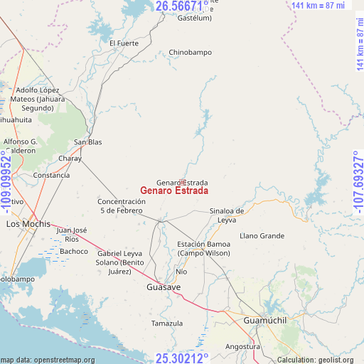
Genaro Estrada GPS coordinates[2]
25° 56' 9.996" North, 108° 23' 47.004" West
| Map corner | latitude | longitude |
|---|---|---|
| Upper-left | 26.56671°, | -109.09952° |
| Center: | 25.93611°, | -108.39639° |
| Lower-right: | 25.30212°, | -107.69327° |
| Map W x H: | 140.6×140.6 km | = 87.4×87.4mi |
| max Lat: | 32.7° ⇑5% North |
| Genaro Estrada: | 25.93611° |
| min Lat: | ⇓95% South 14.53588° |
| min Long | Genaro Estrada | max Long |
| -117.105° | -108.39639° | -86.73105° |
| W 3.9%⇐ | ⇒96.1% E |
Elevation
Elevation of Genaro Estrada is 97 m = 318 ft, and this is 1156.7 m = 3795 ft below average elevation for this country.
| Max E: |
3497 m = 11473 ft | 79.8% |
| Avg. | 1253.7 m = 4113 ft | |
| Genaro Estrada | 97 m = 318 ft | |
Min E: |
-1 m = -3 ft | 20.2% |
See also: Mexico elevation on elevation.city.
Geographical zone
Genaro Estrada is located in North temperate zone (between Tropic of Cancer and the Arctic Circle). Distance of this Northern Tropic circle is 277.9 km =172.7 mi to South.| Distance of | km | miles | from Genaro Estrada |
|---|---|---|---|
| North Pole | 7123.2 | 4426.1 | to North |
| Arctic Circle | 4517.3 | 2806.9 | to North |
| Tropic Cancer | 277.9 | 172.7 | to South |
| Equator | 2883.8 | 1791.9 | to South |


Nearby cities:
15 places around Genaro Estrada: (largest is in red/bold)
• Baburia
22 km =13.7 mi,  118°
118°
• Cubiri de Portelas
21.5 km =13.4 mi,  140°
140°
• Cubiri de la Capilla
19.2 km =11.9 mi,  150°
150°
• Cubiri de la Cuesta
23.3 km =14.5 mi, 150°
• Cubiri de la Loma
23 km =14.3 mi, 147°
• Cubiri de la Máquina
17.4 km =10.8 mi, 139°
• Ejido Playa Segunda
14.6 km =9.1 mi,  193°
193°
• El Alamito
13.1 km =8.1 mi,  219°
219°
• El Caimán
9.2 km =5.7 mi, 138°
• El Opochi
23.5 km =14.6 mi, 124°
• El Zopilote
21.4 km =13.3 mi,  167°
167°
• Gabriel Leyva Velázquez
23.2 km =14.4 mi,  226°
226°
• Naranjo
16.7 km =10.4 mi,  210°
210°
• Portugués de Gálvez
23.2 km =14.4 mi,  179°
179°
• Sinaloa de Leyva
21.5 km =13.4 mi,  126°
126°
Sources, notices
• [Note1] Compared only with cities in Mexico existing in our database
• [Src1] Map data: © OpenStreetMap contributors (CC-BY-SA)
• [Src2] Other city data from geonames.org with taken over terms of usage.
• [Src3] Geographical zone / Annual Mean Temperature by Robert A. Rohde @ Wikipedia
