Las Esperanzas (El Ranchito) geodata
Las Esperanzas (El Ranchito) (Zacatecas) is a populated place; located in Mexico in America/Mexico_City (GMT-6) time zone. With population of 2,425 people, there are 3634 cities with bigger population in this country. Compared to other cities in Mexico, 89.6% of cities are located further ↓South; 86.3% of cities are located further →East and 70.9% of cities have lower elevation than Las Esperanzas (El Ranchito). Note1
Current local time in Las Esperanzas (El Ranchito):
11:32 AM, MondayDifference from your time zone: hours


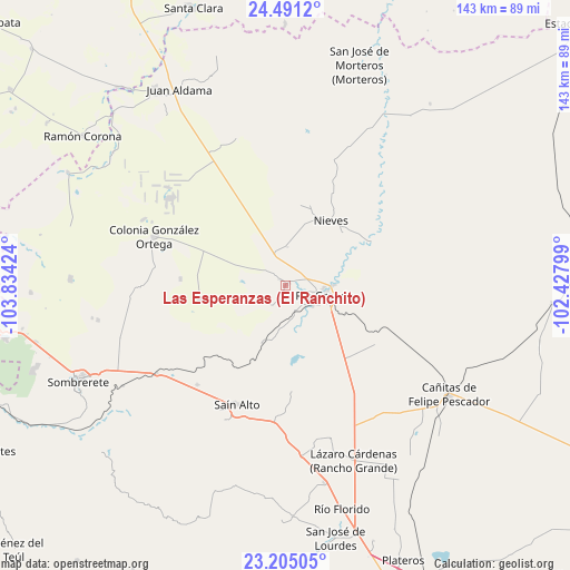
Las Esperanzas (El Ranchito) GPS coordinates[2]
23° 50' 58.992" North, 103° 7' 51.996" West
| Map corner | latitude | longitude |
|---|---|---|
| Upper-left | 24.4912°, | -103.83424° |
| Center: | 23.84972°, | -103.13111° |
| Lower-right: | 23.20505°, | -102.42799° |
| Map W x H: | 143×143 km | = 88.9×88.9mi |
| max Lat: | 32.7° ⇑10.4% North |
| Las Esperanzas (El Ranchito): | 23.84972° |
| min Lat: | ⇓89.6% South 14.53588° |
| min Long | Las Esperanzas | max Long |
| -117.105° | -103.13111° | -86.73105° |
| W 13.7%⇐ | ⇒86.3% E |
Elevation
Elevation of Las Esperanzas (El Ranchito) is 1942 m = 6371 ft, and this is 688.3 m = 2258 ft above average elevation for this country.
| Max E: |
3497 m = 11473 ft | 29.1% |
| Las Esperanzas (El Ranchito) | 1942 m 6371 ft | |
| Avg. | 1253.7 m = 4113 ft | |
Min E: |
-1 m = -3 ft | 70.9% |
See also: Mexico elevation on elevation.city.
Geographical zone
Las Esperanzas (El Ranchito) is located in North temperate zone (between Tropic of Cancer and the Arctic Circle). Distance of this Northern Tropic circle is 45.9 km =28.5 mi to South.| Distance of | km | miles | from Las Esperanzas (El Ranchito) |
|---|---|---|---|
| North Pole | 7355.2 | 4570.3 | to North |
| Arctic Circle | 4749.3 | 2951.1 | to North |
| Tropic Cancer | 45.9 | 28.5 | to South |
| Equator | 2651.8 | 1647.8 | to South |


Nearby cities:
15 places around Las Esperanzas (El Ranchito): (largest is in red/bold)
• Ciénega y Mancilla
8.8 km =5.5 mi,  136°
136°
• Colonia Francisco García Salinas
6.7 km =4.2 mi,  230°
230°
• El Fuerte
1 km =0.6 mi,  61°
61°
• Ignacio López Rayón (Los Delgado)
7.1 km =4.4 mi,  120°
120°
• José María Morelos y Pavón
1.8 km =1.1 mi,  323°
323°
• La Estanzuela
9.7 km =6 mi,  3°
3°
• La Florida
7.5 km =4.7 mi,  131°
131°
• Las Piedras
8.7 km =5.4 mi, 127°
• Loreto
12.2 km =7.6 mi,  89°
89°
• Los Condes
5.5 km =3.4 mi,  102°
102°
• Los Ramírez
9.8 km =6.1 mi, 93°
• Pastelera
12.2 km =7.6 mi,  163°
163°
• Río Grande
10.6 km =6.6 mi, 104°
• San Felipe
7.2 km =4.5 mi, 160°
• Tierra Blanca
6.1 km =3.8 mi,  114°
114°
Sources, notices
• [Note1] Compared only with cities in Mexico existing in our database
• [Src1] Map data: © OpenStreetMap contributors (CC-BY-SA)
• [Src2] Other city data from geonames.org with taken over terms of usage.
• [Src3] Geographical zone / Annual Mean Temperature by Robert A. Rohde @ Wikipedia
