Manuel Villalongín geodata
Manuel Villalongín (Michoacán) is a populated place; located in Mexico in America/Mexico_City (GMT-6) time zone. With population of 1,906 people, there are 4563 cities with bigger population in this country. Compared to other cities in Mexico, 62.2% of cities are located further ↓South; 77.6% of cities are located further →East and 59.4% of cities have lower elevation than Manuel Villalongín. Note1


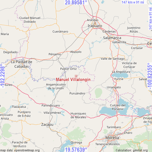
Manuel Villalongín GPS coordinates[2]
20° 14' 15" North, 101° 31' 36.012" West
| Map corner | latitude | longitude |
|---|---|---|
| Upper-left | 20.89581°, | -102.2298° |
| Center: | 20.2375°, | -101.52667° |
| Lower-right: | 19.57639°, | -100.82355° |
| Map W x H: | 146.7×146.7 km | = 91.2×91.2mi |
| max Lat: | 32.7° ⇑37.8% North |
| Manuel Villalongín: | 20.2375° |
| min Lat: | ⇓62.2% South 14.53588° |
| min Long | Manuel Villalon | max Long |
| -117.105° | -101.52667° | -86.73105° |
| W 22.4%⇐ | ⇒77.6% E |
Elevation
Elevation of Manuel Villalongín is 1716 m = 5630 ft, and this is 462.3 m = 1517 ft above average elevation for this country.
| Max E: |
3497 m = 11473 ft | 40.6% |
| Manuel Villalongín | 1716 m 5630 ft | |
| Avg. | 1253.7 m = 4113 ft | |
Min E: |
-1 m = -3 ft | 59.4% |
See also: Mexico elevation on elevation.city.
Geographical zone
Manuel Villalongín is located in North Torrid zone (between Equator and Tropic of Cancer). Distance of this Northern Tropic circle is 355.7 km =221 mi to North.| Distance of | km | miles | from Manuel Villalongín |
|---|---|---|---|
| North Pole | 7756.9 | 4819.9 | to North |
| Arctic Circle | 5151 | 3200.7 | to North |
| Tropic Cancer | 355.7 | 221 | to North |
| Equator | 2250.2 | 1398.2 | to South |


Nearby cities:
15 places around Manuel Villalongín: (largest is in red/bold)
• El Arco
5.2 km =3.2 mi,  291°
291°
• Huatajo
8.6 km =5.3 mi,  139°
139°
• Héroes de Chapultepec (Rodeo de San Antonio)
8.6 km =5.3 mi,  17°
17°
• Isaac Arriaga (Santa Ana Mancera)
3.6 km =2.2 mi,  74°
74°
• Janambo
3.5 km =2.2 mi,  179°
179°
• La Calera (Nacimientos)
6.6 km =4.1 mi,  309°
309°
• La Soledad de Santa Ana
5.9 km =3.7 mi,  51°
51°
• Las Letras
9.7 km =6 mi,  94°
94°
• Las Ranas
6 km =3.7 mi,  122°
122°
• Los Corrales
9.9 km =6.2 mi,  331°
331°
• San José Huipana
7.4 km =4.6 mi, 53°
• San José del Reparo
3.4 km =2.1 mi,  168°
168°
• San Martín
9.2 km =5.7 mi,  254°
254°
• San Nicolás
6.7 km =4.2 mi, 172°
• Tafolla (José María Tafolla)
3 km =1.9 mi,  297°
297°
Sources, notices
• [Note1] Compared only with cities in Mexico existing in our database
• [Src1] Map data: © OpenStreetMap contributors (CC-BY-SA)
• [Src2] Other city data from geonames.org with taken over terms of usage.
• [Src3] Geographical zone / Annual Mean Temperature by Robert A. Rohde @ Wikipedia
