San José del Reparo geodata
San José del Reparo (Michoacán) is a populated place; located in Mexico in America/Mexico_City (GMT-6) time zone. With population of 913 people, there are 9556 cities with bigger population in this country. Compared to other cities in Mexico, 61.5% of cities are located further ↓South; 77.6% of cities are located further →East and 64.1% of cities have lower elevation than San José del Reparo. Note1


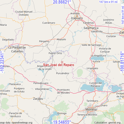
San José del Reparo GPS coordinates[2]
20° 12' 28.008" North, 101° 31' 13.008" West
| Map corner | latitude | longitude |
|---|---|---|
| Upper-left | 20.86621°, | -102.22341° |
| Center: | 20.20778°, | -101.52028° |
| Lower-right: | 19.54655°, | -100.81716° |
| Map W x H: | 146.7×146.7 km | = 91.2×91.2mi |
| max Lat: | 32.7° ⇑38.5% North |
| San José del Reparo: | 20.20778° |
| min Lat: | ⇓61.5% South 14.53588° |
| min Long | San José del R | max Long |
| -117.105° | -101.52028° | -86.73105° |
| W 22.4%⇐ | ⇒77.6% E |
Elevation
Elevation of San José del Reparo is 1804 m = 5919 ft, and this is 550.3 m = 1805 ft above average elevation for this country.
| Max E: |
3497 m = 11473 ft | 35.9% |
| San José del Reparo | 1804 m 5919 ft | |
| Avg. | 1253.7 m = 4113 ft | |
Min E: |
-1 m = -3 ft | 64.1% |
See also: Mexico elevation on elevation.city.
Geographical zone
San José del Reparo is located in North Torrid zone (between Equator and Tropic of Cancer). Distance of this Northern Tropic circle is 359 km =223.1 mi to North.| Distance of | km | miles | from San José del Reparo |
|---|---|---|---|
| North Pole | 7760.2 | 4822 | to North |
| Arctic Circle | 5154.3 | 3202.7 | to North |
| Tropic Cancer | 359 | 223.1 | to North |
| Equator | 2246.9 | 1396.2 | to South |


Nearby cities:
15 places around San José del Reparo: (largest is in red/bold)
• El Arco
7.5 km =4.7 mi,  313°
313°
• Huatajo
5.9 km =3.7 mi,  123°
123°
• Isaac Arriaga (Santa Ana Mancera)
5.1 km =3.2 mi,  33°
33°
• Janambo
0.7 km =0.4 mi,  256°
256°
• La Calera (Nacimientos)
9.5 km =5.9 mi,  322°
322°
• La Excusa
7.7 km =4.8 mi,  158°
158°
• La Soledad de Santa Ana
8 km =5 mi, 29°
• Las Letras
9.4 km =5.8 mi,  74°
74°
• Las Ranas
4.4 km =2.7 mi,  88°
88°
• Manuel Villalongín
3.4 km =2.1 mi,  348°
348°
• San José Huipana
9.4 km =5.8 mi, 34°
• San Martín
9.5 km =5.9 mi,  275°
275°
• San Nicolás
3.3 km =2.1 mi,  176°
176°
• San Pedro (San Pedro Carano)
8.7 km =5.4 mi, 175°
• Tafolla (José María Tafolla)
5.7 km =3.5 mi, 324°
Sources, notices
• [Note1] Compared only with cities in Mexico existing in our database
• [Src1] Map data: © OpenStreetMap contributors (CC-BY-SA)
• [Src2] Other city data from geonames.org with taken over terms of usage.
• [Src3] Geographical zone / Annual Mean Temperature by Robert A. Rohde @ Wikipedia
