Aguas Calientes geodata
Aguas Calientes (Guerrero) is a populated place; located in Mexico in America/Mexico_City (GMT-6) time zone. With population of 1,660 people, there are 5235 cities with bigger population in this country. Compared to other cities in Mexico, 91.1% of cities are located further ↑North; 59.3% of cities are located further →East and 87% of cities have higher elevation than Aguas Calientes. Note1


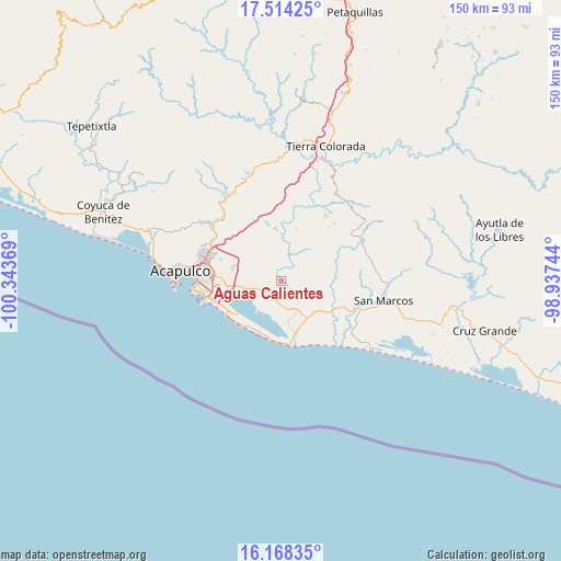
Aguas Calientes GPS coordinates[2]
16° 50' 33" North, 99° 38' 26.016" West
| Map corner | latitude | longitude |
|---|---|---|
| Upper-left | 17.51425°, | -100.34369° |
| Center: | 16.8425°, | -99.64056° |
| Lower-right: | 16.16835°, | -98.93744° |
| Map W x H: | 149.7×149.7 km | = 93×93mi |
| max Lat: | 32.7° ⇑91.1% North |
| Aguas Calientes: | 16.8425° |
| min Lat: | ⇓8.9% South 14.53588° |
| min Long | Aguas Calientes | max Long |
| -117.105° | -99.64056° | -86.73105° |
| W 40.7%⇐ | ⇒59.3% E |
Elevation
Elevation of Aguas Calientes is 34 m = 112 ft, and this is 1219.7 m = 4002 ft below average elevation for this country.
| Max E: |
3497 m = 11473 ft | 87% |
| Avg. | 1253.7 m = 4113 ft | |
| Aguas Calientes | 34 m = 112 ft | |
Min E: |
-1 m = -3 ft | 13% |
See also: Mexico elevation on elevation.city.
Geographical zone
Aguas Calientes is located in North Torrid zone (between Equator and Tropic of Cancer). Distance of this Northern Tropic circle is 733.2 km =455.6 mi to North.| Distance of | km | miles | from Aguas Calientes |
|---|---|---|---|
| North Pole | 8134.4 | 5054.5 | to North |
| Arctic Circle | 5528.5 | 3435.2 | to North |
| Tropic Cancer | 733.2 | 455.6 | to North |
| Equator | 1872.7 | 1163.6 | to South |


Nearby cities:
15 places around Aguas Calientes: (largest is in red/bold)
• Amatillo
3.7 km =2.3 mi,  227°
227°
• Apalani
5.6 km =3.5 mi,  77°
77°
• Bella Vista Papagayo
8.7 km =5.4 mi,  150°
150°
• Cacahuatepec
5.8 km =3.6 mi,  30°
30°
• Campanario
7.4 km =4.6 mi,  96°
96°
• Cerro de Piedra
7.4 km =4.6 mi,  171°
171°
• El Bejuco
7.4 km =4.6 mi,  254°
254°
• El Cantón
7.4 km =4.6 mi,  38°
38°
• La Concepción
4.2 km =2.6 mi,  343°
343°
• La Estación
8.8 km =5.5 mi,  198°
198°
• Las Cruces de Cacahuatepec
2.7 km =1.7 mi, 78°
• Oaxaquillas
2.7 km =1.7 mi,  220°
220°
• San Antonio
4.9 km =3 mi, 201°
• San Pedro Cacahuatepec
4.3 km =2.7 mi, 224°
• Tasajeras
4.4 km =2.7 mi, 145°
Sources, notices
• [Note1] Compared only with cities in Mexico existing in our database
• [Src1] Map data: © OpenStreetMap contributors (CC-BY-SA)
• [Src2] Other city data from geonames.org with taken over terms of usage.
• [Src3] Geographical zone / Annual Mean Temperature by Robert A. Rohde @ Wikipedia
