La Estación geodata
La Estación (Guerrero) is a populated place; located in Mexico in America/Mexico_City (GMT-6) time zone. With population of 1,366 people, there are 6362 cities with bigger population in this country. Compared to other cities in Mexico, 92.1% of cities are located further ↑North; 59.7% of cities are located further →East and 89.4% of cities have higher elevation than La Estación. Note1


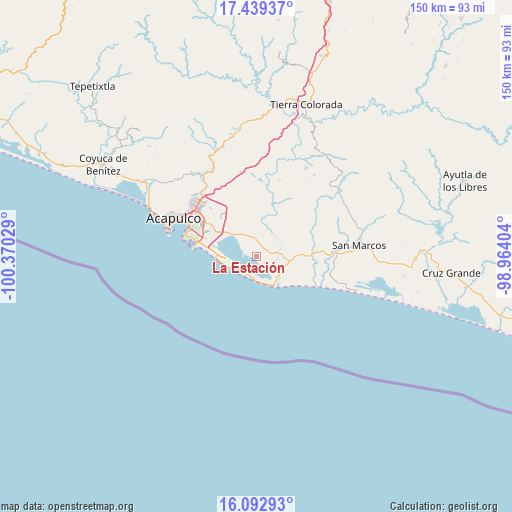
La Estación GPS coordinates[2]
16° 46' 2.424" North, 99° 40' 1.776" West
| Map corner | latitude | longitude |
|---|---|---|
| Upper-left | 17.43937°, | -100.37029° |
| Center: | 16.76734°, | -99.66716° |
| Lower-right: | 16.09293°, | -98.96404° |
| Map W x H: | 149.7×149.7 km | = 93×93mi |
| max Lat: | 32.7° ⇑92.1% North |
| La Estación: | 16.76734° |
| min Lat: | ⇓7.9% South 14.53588° |
| min Long | La Estación | max Long |
| -117.105° | -99.66716° | -86.73105° |
| W 40.3%⇐ | ⇒59.7% E |
Elevation
Elevation of La Estación is 26 m = 85 ft, and this is 1227.7 m = 4028 ft below average elevation for this country.
| Max E: |
3497 m = 11473 ft | 89.4% |
| Avg. | 1253.7 m = 4113 ft | |
| La Estación | 26 m = 85 ft | |
Min E: |
-1 m = -3 ft | 10.6% |
See also: Mexico elevation on elevation.city.
Geographical zone
La Estación is located in North Torrid zone (between Equator and Tropic of Cancer). Distance of this Northern Tropic circle is 741.6 km =460.8 mi to North.| Distance of | km | miles | from La Estación |
|---|---|---|---|
| North Pole | 8142.7 | 5059.6 | to North |
| Arctic Circle | 5536.8 | 3440.4 | to North |
| Tropic Cancer | 741.6 | 460.8 | to North |
| Equator | 1864.4 | 1158.5 | to South |


Nearby cities:
15 places around La Estación: (largest is in red/bold)
• Aguas Calientes
8.8 km =5.5 mi,  18°
18°
• Amatillo
5.9 km =3.7 mi,  1°
1°
• Barra Vieja
9.5 km =5.9 mi,  152°
152°
• Bella Vista Papagayo
7.1 km =4.4 mi,  84°
84°
• Cerro de Piedra
4 km =2.5 mi, 75°
• El Arenal
5.6 km =3.5 mi,  301°
301°
• El Bejuco
7.7 km =4.8 mi,  326°
326°
• Las Cruces de Cacahuatepec
10.4 km =6.5 mi,  31°
31°
• Lomas de Chapultepec
8.3 km =5.2 mi,  133°
133°
• Oaxaquillas
6.4 km =4 mi,  9°
9°
• San Andrés Playa Encantada (El Podrido)
9.1 km =5.7 mi,  157°
157°
• San Antonio
3.9 km =2.4 mi, 15°
• San Pedro Cacahuatepec
5.3 km =3.3 mi,  358°
358°
• San Pedro las Playas
9.2 km =5.7 mi,  311°
311°
• Tasajeras
7.1 km =4.4 mi,  48°
48°
Sources, notices
• [Note1] Compared only with cities in Mexico existing in our database
• [Src1] Map data: © OpenStreetMap contributors (CC-BY-SA)
• [Src2] Other city data from geonames.org with taken over terms of usage.
• [Src3] Geographical zone / Annual Mean Temperature by Robert A. Rohde @ Wikipedia
