El Bejuco geodata
El Bejuco (Guerrero) is a populated place; located in Mexico in America/Mexico_City (GMT-6) time zone. With population of 2,271 people, there are 3878 cities with bigger population in this country. Compared to other cities in Mexico, 91.3% of cities are located further ↑North; 60.3% of cities are located further →East and 90.4% of cities have higher elevation than El Bejuco. Note1


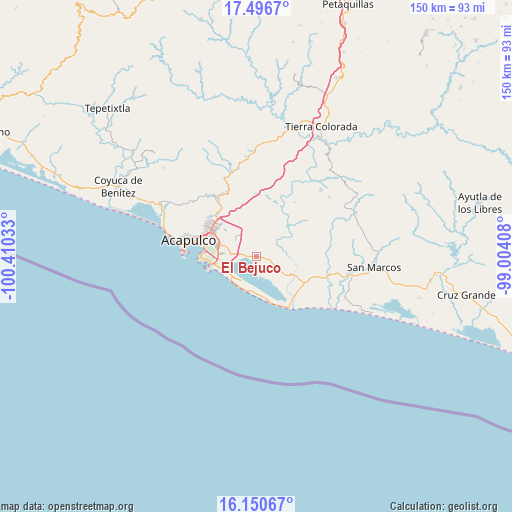
El Bejuco GPS coordinates[2]
16° 49' 29.568" North, 99° 42' 25.92" West
| Map corner | latitude | longitude |
|---|---|---|
| Upper-left | 17.4967°, | -100.41033° |
| Center: | 16.82488°, | -99.7072° |
| Lower-right: | 16.15067°, | -99.00408° |
| Map W x H: | 149.7×149.7 km | = 93×93mi |
| max Lat: | 32.7° ⇑91.3% North |
| El Bejuco: | 16.82488° |
| min Lat: | ⇓8.7% South 14.53588° |
| min Long | El Bejuco | max Long |
| -117.105° | -99.7072° | -86.73105° |
| W 39.7%⇐ | ⇒60.3% E |
Elevation
Elevation of El Bejuco is 23 m = 75 ft, and this is 1230.7 m = 4038 ft below average elevation for this country.
| Max E: |
3497 m = 11473 ft | 90.4% |
| Avg. | 1253.7 m = 4113 ft | |
| El Bejuco | 23 m = 75 ft | |
Min E: |
-1 m = -3 ft | 9.6% |
See also: Mexico elevation on elevation.city.
Geographical zone
El Bejuco is located in North Torrid zone (between Equator and Tropic of Cancer). Distance of this Northern Tropic circle is 735.2 km =456.8 mi to North.| Distance of | km | miles | from El Bejuco |
|---|---|---|---|
| North Pole | 8136.3 | 5055.7 | to North |
| Arctic Circle | 5530.4 | 3436.4 | to North |
| Tropic Cancer | 735.2 | 456.8 | to North |
| Equator | 1870.8 | 1162.5 | to South |


Nearby cities:
15 places around El Bejuco: (largest is in red/bold)
• 10 de Abril
3.6 km =2.2 mi,  277°
277°
• Aguas Calientes
7.4 km =4.6 mi,  74°
74°
• Amatillo
4.4 km =2.7 mi,  96°
96°
• El Arenal
3.5 km =2.2 mi,  188°
188°
• El Metlapil
4.8 km =3 mi,  292°
292°
• El Salto
7.6 km =4.7 mi,  305°
305°
• La Concepción
8.4 km =5.2 mi,  44°
44°
• La Estación
7.7 km =4.8 mi,  146°
146°
• Nicolás Bravo (Zanja del Teniente)
4.4 km =2.7 mi, 281°
• Oaxaquillas
5.3 km =3.3 mi,  91°
91°
• San Antonio
5.9 km =3.7 mi,  116°
116°
• San Isidro Gallinero (El Gallinero)
6.3 km =3.9 mi,  353°
353°
• San Pedro Cacahuatepec
4.3 km =2.7 mi, 104°
• San Pedro las Playas
2.6 km =1.6 mi,  265°
265°
• Tres Palos
7.6 km =4.7 mi, 273°
Sources, notices
• [Note1] Compared only with cities in Mexico existing in our database
• [Src1] Map data: © OpenStreetMap contributors (CC-BY-SA)
• [Src2] Other city data from geonames.org with taken over terms of usage.
• [Src3] Geographical zone / Annual Mean Temperature by Robert A. Rohde @ Wikipedia
