Melitón Albáñez Domínguez geodata
Melitón Albáñez Domínguez (Baja California Sur) is a populated place; located in Mexico in America/Mazatlan (GMT-7) time zone. With population of 1,588 people, there are 5434 cities with bigger population in this country. Compared to other cities in Mexico, 89.2% of cities are located further ↓South; 98.4% of cities are located further →East and 86.7% of cities have higher elevation than Melitón Albáñez Domínguez. Note1
Current local time in Melitón Albáñez Domínguez:
06:18 AM, MondayDifference from your time zone: hours


Melitón Albáñez Domínguez GPS coordinates[2]
23° 39' 41.004" North, 110° 25' 14.988" West
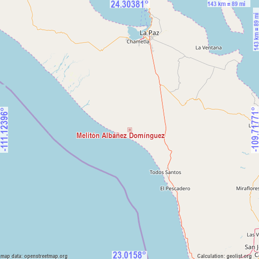
| Map corner | latitude | longitude |
|---|---|---|
| Upper-left | 24.30381°, | -111.12396° |
| Center: | 23.66139°, | -110.42083° |
| Lower-right: | 23.0158°, | -109.71771° |
| Map W x H: | 143.2×143.2 km | = 89×89mi |
| max Lat: | 32.7° ⇑10.8% North |
| Melitón Albáñez Domínguez: | 23.66139° |
| min Lat: | ⇓89.2% South 14.53588° |
| min Long | Melitón Albá� | max Long |
| -117.105° | -110.42083° | -86.73105° |
| W 1.6%⇐ | ⇒98.4% E |
Elevation
Elevation of Melitón Albáñez Domínguez is 35 m = 115 ft, and this is 1218.7 m = 3998 ft below average elevation for this country.
| Max E: |
3497 m = 11473 ft | 86.7% |
| Avg. | 1253.7 m = 4113 ft | |
| Melitón Albáñez Domínguez | 35 m = 115 ft | |
Min E: |
-1 m = -3 ft | 13.3% |
See also: Mexico elevation on elevation.city.
Geographical zone
Melitón Albáñez Domínguez is located in North temperate zone (between Tropic of Cancer and the Arctic Circle). Distance of this Northern Tropic circle is 25 km =15.5 mi to South.| Distance of | km | miles | from Melitón Albáñez Domínguez |
|---|---|---|---|
| North Pole | 7376.2 | 4583.4 | to North |
| Arctic Circle | 4770.3 | 2964.1 | to North |
| Tropic Cancer | 25 | 15.5 | to South |
| Equator | 2630.9 | 1634.8 | to South |


Nearby cities:
15 places around Melitón Albáñez Domínguez: (largest is in red/bold)
• Buena Vista
75.1 km =46.7 mi,  91°
91°
• Chametla
48.9 km =30.4 mi,  5°
5°
• El Cachanilla
15.4 km =9.6 mi,  66°
66°
• El Carrizal
17.6 km =10.9 mi,  39°
39°
• El Centenario
49.1 km =30.5 mi,  0°
0°
• El Pescadero
41.9 km =26 mi,  142°
142°
• El Sargento
63.9 km =39.7 mi, 42°
• General Juán Domínguez Cota
59 km =36.7 mi,  54°
54°
• La Paz
55.1 km =34.2 mi, 12°
• Los Barriles
73.5 km =45.7 mi, 88°
• Miraflores
73.5 km =45.7 mi,  116°
116°
• San Juan de los Planes
59.9 km =37.2 mi,  55°
55°
• San Pedro
33.5 km =20.8 mi,  28°
28°
• Santiago
74.7 km =46.4 mi,  105°
105°
• Todos Santos
31.2 km =19.4 mi, 139°
Sources, notices
• [Note1] Compared only with cities in Mexico existing in our database
• [Src1] Map data: © OpenStreetMap contributors (CC-BY-SA)
• [Src2] Other city data from geonames.org with taken over terms of usage.
• [Src3] Geographical zone / Annual Mean Temperature by Robert A. Rohde @ Wikipedia
