Chametla geodata
Chametla (Baja California Sur) is a populated place; located in Mexico in America/Mazatlan (GMT-7) time zone. With population of 2,178 people, there are 4035 cities with bigger population in this country. Compared to other cities in Mexico, 90.3% of cities are located further ↓South; 98.4% of cities are located further →East and 98.1% of cities have higher elevation than Chametla. Note1


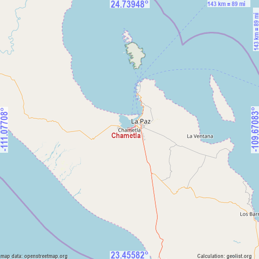
Chametla GPS coordinates[2]
24° 5' 57.336" North, 110° 22' 26.22" West
| Map corner | latitude | longitude |
|---|---|---|
| Upper-left | 24.73948°, | -111.07708° |
| Center: | 24.09926°, | -110.37395° |
| Lower-right: | 23.45582°, | -109.67083° |
| Map W x H: | 142.7×142.7 km | = 88.7×88.7mi |
| max Lat: | 32.7° ⇑9.7% North |
| Chametla: | 24.09926° |
| min Lat: | ⇓90.3% South 14.53588° |
| min Long | Chametla | max Long |
| -117.105° | -110.37395° | -86.73105° |
| W 1.6%⇐ | ⇒98.4% E |
Elevation
Elevation of Chametla is 8 m = 26 ft, and this is 1245.7 m = 4087 ft below average elevation for this country.
| Max E: |
3497 m = 11473 ft | 98.1% |
| Avg. | 1253.7 m = 4113 ft | |
| Chametla | 8 m = 26 ft | |
Min E: |
-1 m = -3 ft | 1.9% |
See also: Mexico elevation on elevation.city.
Geographical zone
Chametla is located in North temperate zone (between Tropic of Cancer and the Arctic Circle). Distance of this Northern Tropic circle is 73.7 km =45.8 mi to South.| Distance of | km | miles | from Chametla |
|---|---|---|---|
| North Pole | 7327.5 | 4553.1 | to North |
| Arctic Circle | 4721.6 | 2933.9 | to North |
| Tropic Cancer | 73.7 | 45.8 | to South |
| Equator | 2679.6 | 1665 | to South |


Nearby cities:
15 places around Chametla: (largest is in red/bold)
• Buena Vista
86.4 km =53.7 mi,  125°
125°
• El Cachanilla
43.4 km =27 mi,  167°
167°
• El Campamento
94 km =58.4 mi, 131°
• El Carrizal
35.6 km =22.1 mi, 169°
• El Centenario
4.1 km =2.5 mi,  275°
275°
• El Pescadero
84.4 km =52.4 mi, 165°
• El Sargento
38.6 km =24 mi,  92°
92°
• General Juán Domínguez Cota
45.2 km =28.1 mi,  108°
108°
• La Paz
9 km =5.6 mi,  56°
56°
• Los Barriles
82.7 km =51.4 mi,  124°
124°
• Melitón Albáñez Domínguez
48.9 km =30.4 mi,  185°
185°
• San Juan de los Planes
46.9 km =29.1 mi, 108°
• San Pedro
22.3 km =13.9 mi,  149°
149°
• Santiago
96.2 km =59.8 mi,  135°
135°
• Todos Santos
74.1 km =46 mi, 168°
Sources, notices
• [Note1] Compared only with cities in Mexico existing in our database
• [Src1] Map data: © OpenStreetMap contributors (CC-BY-SA)
• [Src2] Other city data from geonames.org with taken over terms of usage.
• [Src3] Geographical zone / Annual Mean Temperature by Robert A. Rohde @ Wikipedia
