Villa Hermosa (Las Pozas) geodata
Villa Hermosa (Las Pozas) (Guerrero) is a populated place; located in Mexico in America/Mexico_City (GMT-6) time zone. With population of 1,519 people, there are 5675 cities with bigger population in this country. Compared to other cities in Mexico, 82% of cities are located further ↑North; 77.1% of cities are located further →East and 91.2% of cities have higher elevation than Villa Hermosa (Las Pozas). Note1
Current local time in Villa Hermosa (Las Pozas):
08:29 AM, WednesdayDifference from your time zone: hours


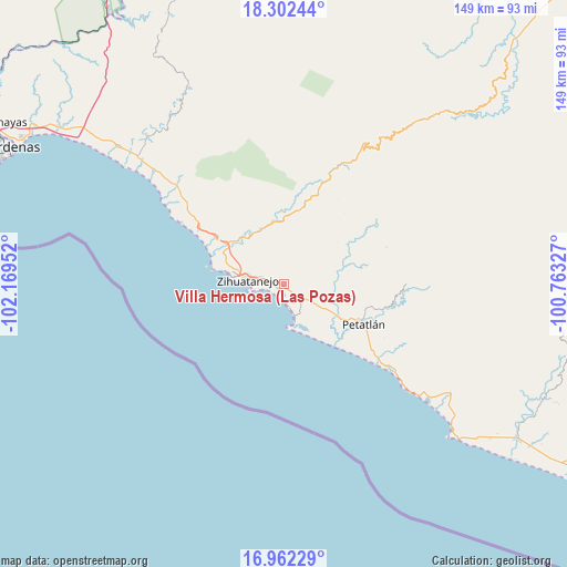
Villa Hermosa (Las Pozas) GPS coordinates[2]
17° 38' 0.996" North, 101° 27' 59.004" West
| Map corner | latitude | longitude |
|---|---|---|
| Upper-left | 18.30244°, | -102.16952° |
| Center: | 17.63361°, | -101.46639° |
| Lower-right: | 16.96229°, | -100.76327° |
| Map W x H: | 149×149 km | = 92.6×92.6mi |
| max Lat: | 32.7° ⇑82% North |
| Villa Hermosa (Las Pozas): | 17.63361° |
| min Lat: | ⇓18% South 14.53588° |
| min Long | Villa Hermosa ( | max Long |
| -117.105° | -101.46639° | -86.73105° |
| W 22.9%⇐ | ⇒77.1% E |
Elevation
Elevation of Villa Hermosa (Las Pozas) is 21 m = 69 ft, and this is 1232.7 m = 4044 ft below average elevation for this country.
| Max E: |
3497 m = 11473 ft | 91.2% |
| Avg. | 1253.7 m = 4113 ft | |
| Villa Hermosa (Las Pozas) | 21 m = 69 ft | |
Min E: |
-1 m = -3 ft | 8.8% |
See also: Mexico elevation on elevation.city.
Geographical zone
Villa Hermosa (Las Pozas) is located in North Torrid zone (between Equator and Tropic of Cancer). Distance of this Northern Tropic circle is 645.2 km =400.9 mi to North.| Distance of | km | miles | from Villa Hermosa (Las Pozas) |
|---|---|---|---|
| North Pole | 8046.4 | 4999.8 | to North |
| Arctic Circle | 5440.5 | 3380.6 | to North |
| Tropic Cancer | 645.2 | 400.9 | to North |
| Equator | 1960.7 | 1218.3 | to South |


Nearby cities:
15 places around Villa Hermosa (Las Pozas): (largest is in red/bold)
• Barbulillas
16.2 km =10.1 mi,  290°
290°
• Colonia Aeropuerto
1.7 km =1.1 mi,  151°
151°
• Colonia Vista Mar
5.5 km =3.4 mi,  126°
126°
• El Coacoyul
1.1 km =0.7 mi,  296°
296°
• El Posquelite
11.5 km =7.1 mi, 293°
• El Zarco
6.4 km =4 mi,  106°
106°
• Ixtapa-Zihuatanejo
9.1 km =5.7 mi,  276°
276°
• La Salitrera
17.3 km =10.7 mi, 303°
• Los Achotes
6.4 km =4 mi, 125°
• Los Almendros
3.8 km =2.4 mi, 130°
• Los Reyes (Las Chiveras)
2.7 km =1.7 mi, 285°
• Palos Blancos
16.5 km =10.3 mi,  120°
120°
• San Jeronimito
14.7 km =9.1 mi, 119°
• San José Ixtapa (Barrio Viejo)
17.9 km =11.1 mi, 295°
• San Miguelito
3.1 km =1.9 mi,  85°
85°
Sources, notices
• [Note1] Compared only with cities in Mexico existing in our database
• [Src1] Map data: © OpenStreetMap contributors (CC-BY-SA)
• [Src2] Other city data from geonames.org with taken over terms of usage.
• [Src3] Geographical zone / Annual Mean Temperature by Robert A. Rohde @ Wikipedia
