Barbulillas geodata
Barbulillas (Guerrero) is a populated place; located in Mexico in America/Mexico_City (GMT-6) time zone. With population of 647 people, there are 13375 cities with bigger population in this country. Compared to other cities in Mexico, 81.4% of cities are located further ↑North; 78.3% of cities are located further →East and 94% of cities have higher elevation than Barbulillas. Note1


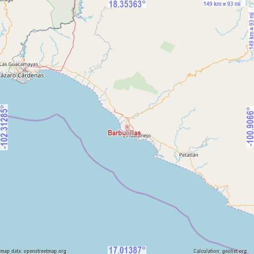
Barbulillas GPS coordinates[2]
17° 41' 6" North, 101° 36' 34.992" West
| Map corner | latitude | longitude |
|---|---|---|
| Upper-left | 18.35363°, | -102.31285° |
| Center: | 17.685°, | -101.60972° |
| Lower-right: | 17.01387°, | -100.9066° |
| Map W x H: | 149×149 km | = 92.6×92.6mi |
| max Lat: | 32.7° ⇑81.4% North |
| Barbulillas: | 17.685° |
| min Lat: | ⇓18.6% South 14.53588° |
| min Long | Barbulillas | max Long |
| -117.105° | -101.60972° | -86.73105° |
| W 21.7%⇐ | ⇒78.3% E |
Elevation
Elevation of Barbulillas is 15 m = 49 ft, and this is 1238.7 m = 4064 ft below average elevation for this country.
| Max E: |
3497 m = 11473 ft | 94% |
| Avg. | 1253.7 m = 4113 ft | |
| Barbulillas | 15 m = 49 ft | |
Min E: |
-1 m = -3 ft | 6% |
See also: Mexico elevation on elevation.city.
Geographical zone
Barbulillas is located in North Torrid zone (between Equator and Tropic of Cancer). Distance of this Northern Tropic circle is 639.5 km =397.4 mi to North.| Distance of | km | miles | from Barbulillas |
|---|---|---|---|
| North Pole | 8040.7 | 4996.3 | to North |
| Arctic Circle | 5434.8 | 3377 | to North |
| Tropic Cancer | 639.5 | 397.4 | to North |
| Equator | 1966.4 | 1221.9 | to South |


Nearby cities:
15 places around Barbulillas: (largest is in red/bold)
• Barrio Nuevo
4.9 km =3 mi,  324°
324°
• Colonia Aeropuerto
17.5 km =10.9 mi,  114°
114°
• El Coacoyul
15.1 km =9.4 mi, 110°
• El Posquelite
4.7 km =2.9 mi,  103°
103°
• Ixtapa
3.9 km =2.4 mi,  240°
240°
• Ixtapa-Zihuatanejo
7.7 km =4.8 mi,  127°
127°
• La Salitrera
3.8 km =2.4 mi,  10°
10°
• Lagunillas
18.8 km =11.7 mi,  325°
325°
• Los Almendros
19.8 km =12.3 mi, 114°
• Los Reyes (Las Chiveras)
13.5 km =8.4 mi, 111°
• Pantla
6.6 km =4.1 mi, 334°
• San José Ixtapa (Barrio Viejo)
2.2 km =1.4 mi, 331°
• San Miguelito
19 km =11.8 mi, 106°
• Troncones
15.7 km =9.8 mi,  311°
311°
• Villa Hermosa (Las Pozas)
16.2 km =10.1 mi, 110°
Sources, notices
• [Note1] Compared only with cities in Mexico existing in our database
• [Src1] Map data: © OpenStreetMap contributors (CC-BY-SA)
• [Src2] Other city data from geonames.org with taken over terms of usage.
• [Src3] Geographical zone / Annual Mean Temperature by Robert A. Rohde @ Wikipedia
