Ixtapa-Zihuatanejo geodata
Ixtapa-Zihuatanejo (Guerrero) is a populated place; located in Mexico in America/Mexico_City (GMT-6) time zone. With population of 67,408 people, there are 179 cities with bigger population in this country. Compared to other cities in Mexico, 81.8% of cities are located further ↑North; 77.8% of cities are located further →East and 95.1% of cities have higher elevation than Ixtapa-Zihuatanejo. Note1


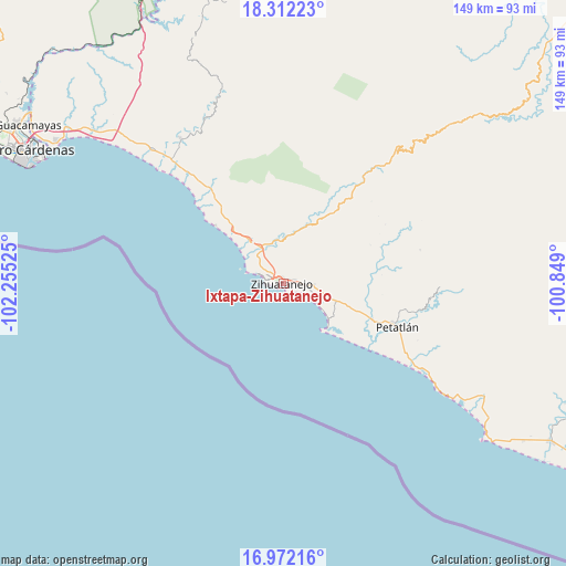
Ixtapa-Zihuatanejo GPS coordinates[2]
17° 38' 36.384" North, 101° 33' 7.632" West
| Map corner | latitude | longitude |
|---|---|---|
| Upper-left | 18.31223°, | -102.25525° |
| Center: | 17.64344°, | -101.55212° |
| Lower-right: | 16.97216°, | -100.849° |
| Map W x H: | 149×149 km | = 92.6×92.6mi |
| max Lat: | 32.7° ⇑81.8% North |
| Ixtapa-Zihuatanejo: | 17.64344° |
| min Lat: | ⇓18.2% South 14.53588° |
| min Long | Ixtapa-Zihuatan | max Long |
| -117.105° | -101.55212° | -86.73105° |
| W 22.2%⇐ | ⇒77.8% E |
Elevation
Elevation of Ixtapa-Zihuatanejo is 13 m = 43 ft, and this is 1240.7 m = 4071 ft below average elevation for this country.
| Max E: |
3497 m = 11473 ft | 95.1% |
| Avg. | 1253.7 m = 4113 ft | |
| Ixtapa-Zihuatanejo | 13 m = 43 ft | |
Min E: |
-1 m = -3 ft | 4.9% |
See also: Ixtapa-Zihuatanejo elevation on elevation.city.
Geographical zone
Ixtapa-Zihuatanejo is located in North Torrid zone (between Equator and Tropic of Cancer). Distance of this Northern Tropic circle is 644.2 km =400.3 mi to North.| Distance of | km | miles | from Ixtapa-Zihuatanejo |
|---|---|---|---|
| North Pole | 8045.3 | 4999.1 | to North |
| Arctic Circle | 5439.4 | 3379.9 | to North |
| Tropic Cancer | 644.2 | 400.3 | to North |
| Equator | 1961.8 | 1219 | to South |


Nearby cities:
15 places around Ixtapa-Zihuatanejo: (largest is in red/bold)
• Barbulillas
7.7 km =4.8 mi,  307°
307°
• Barrio Nuevo
12.4 km =7.7 mi, 313°
• Colonia Aeropuerto
10.2 km =6.3 mi,  104°
104°
• Colonia Vista Mar
14.2 km =8.8 mi,  107°
107°
• El Coacoyul
8.1 km =5 mi,  94°
94°
• El Posquelite
3.8 km =2.4 mi,  337°
337°
• Ixtapa
9.9 km =6.2 mi,  285°
285°
• La Salitrera
10 km =6.2 mi,  327°
327°
• Los Achotes
15 km =9.3 mi, 108°
• Los Almendros
12.5 km =7.8 mi, 106°
• Los Reyes (Las Chiveras)
6.5 km =4 mi, 93°
• Pantla
13.8 km =8.6 mi,  319°
319°
• San José Ixtapa (Barrio Viejo)
9.7 km =6 mi, 312°
• San Miguelito
12.2 km =7.6 mi, 93°
• Villa Hermosa (Las Pozas)
9.1 km =5.7 mi, 96°
In other languages:
- In Spanish: Zihuatanejo, Ixtapa Zihuatanejo
- In France: Zihuatanejo
- In Russian: Сиуатанехо
Sources, notices
• [Note1] Compared only with cities in Mexico existing in our database
• [Src1] Map data: © OpenStreetMap contributors (CC-BY-SA)
• [Src2] Other city data from geonames.org with taken over terms of usage.
• [Src3] Geographical zone / Annual Mean Temperature by Robert A. Rohde @ Wikipedia
