Niños Héroes geodata
Niños Héroes (Morelos) is a populated place; located in Mexico in America/Mexico_City (GMT-6) time zone. With population of 546 people, there are 15582 cities with bigger population in this country. Compared to other cities in Mexico, 69.3% of cities are located further ↑North; 50.9% of cities are located further ←West and 54.1% of cities have higher elevation than Niños Héroes. Note1


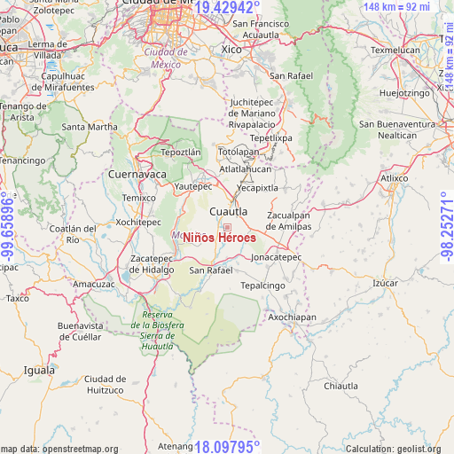
Niños Héroes GPS coordinates[2]
18° 45' 54" North, 98° 57' 20.988" West
| Map corner | latitude | longitude |
|---|---|---|
| Upper-left | 19.42942°, | -99.65896° |
| Center: | 18.765°, | -98.95583° |
| Lower-right: | 18.09795°, | -98.25271° |
| Map W x H: | 148×148 km | = 92×92mi |
| max Lat: | 32.7° ⇑69.3% North |
| Niños Héroes: | 18.765° |
| min Lat: | ⇓30.7% South 14.53588° |
| min Long | Niños Héroes | max Long |
| -117.105° | -98.95583° | -86.73105° |
| W 50.9%⇐ | ⇒49.1% E |
Elevation
Elevation of Niños Héroes is 1237 m = 4058 ft, and this is 16.7 m = 55 ft below average elevation for this country.
| Max E: |
3497 m = 11473 ft | 54.1% |
| Avg. | 1253.7 m = 4113 ft | |
| Niños Héroes | 1237 m = 4058 ft | |
Min E: |
-1 m = -3 ft | 45.9% |
See also: Mexico elevation on elevation.city.
Geographical zone
Niños Héroes is located in North Torrid zone (between Equator and Tropic of Cancer). Distance of this Northern Tropic circle is 519.4 km =322.7 mi to North.| Distance of | km | miles | from Niños Héroes |
|---|---|---|---|
| North Pole | 7920.6 | 4921.6 | to North |
| Arctic Circle | 5314.7 | 3302.4 | to North |
| Tropic Cancer | 519.4 | 322.7 | to North |
| Equator | 2086.5 | 1296.5 | to South |


Nearby cities:
15 places around Niños Héroes: (largest is in red/bold)
• Abelardo L. Rodríguez
4.4 km =2.7 mi,  225°
225°
• Anenecuilco
3.8 km =2.4 mi,  291°
291°
• Ciudad Ayala
2.8 km =1.7 mi,  274°
274°
• Colonia Ejidal Rafael Merino
3.9 km =2.4 mi, 231°
• Colonia las Arboledas
2.8 km =1.7 mi,  36°
36°
• Constancio Farfán (La Pascuala)
2.6 km =1.6 mi,  175°
175°
• Cuautla
5.5 km =3.4 mi,  23°
23°
• Empleado Municipal
5.6 km =3.5 mi,  65°
65°
• Fraccionamiento Huertas de Cuautla
4.6 km =2.9 mi,  90°
90°
• Olintepec
4.3 km =2.7 mi, 230°
• Reforma
3 km =1.9 mi,  49°
49°
• San Pedro Apatlaco
3.1 km =1.9 mi,  352°
352°
• Tenextepango
4 km =2.5 mi, 182°
• Unidad Habitacional 10 de Abril
4.3 km =2.7 mi,  105°
105°
• Valle de Morelos
3.7 km =2.3 mi,  200°
200°
Sources, notices
• [Note1] Compared only with cities in Mexico existing in our database
• [Src1] Map data: © OpenStreetMap contributors (CC-BY-SA)
• [Src2] Other city data from geonames.org with taken over terms of usage.
• [Src3] Geographical zone / Annual Mean Temperature by Robert A. Rohde @ Wikipedia
