Cuautla geodata
Cuautla (Morelos) is a seat of a second-order administrative division; located in Mexico in America/Mexico_City (GMT-6) time zone. With population of 154,358 people, there are 101 cities with bigger population in this country. Compared to other cities in Mexico, 68.6% of cities are located further ↑North; 51.4% of cities are located further ←West and 52.1% of cities have higher elevation than Cuautla. Note1


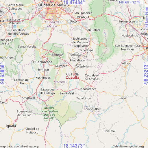
Cuautla GPS coordinates[2]
18° 48' 38.16" North, 98° 56' 6.9" West
| Map corner | latitude | longitude |
|---|---|---|
| Upper-left | 19.47484°, | -99.63838° |
| Center: | 18.8106°, | -98.93525° |
| Lower-right: | 18.14373°, | -98.23213° |
| Map W x H: | 148×148 km | = 92×92mi |
| max Lat: | 32.7° ⇑68.6% North |
| Cuautla: | 18.8106° |
| min Lat: | ⇓31.4% South 14.53588° |
| min Long | Cuautla | max Long |
| -117.105° | -98.93525° | -86.73105° |
| W 51.4%⇐ | ⇒48.6% E |
Elevation
Elevation of Cuautla is 1333 m = 4373 ft, and this is 79.3 m = 260 ft above average elevation for this country.
| Max E: |
3497 m = 11473 ft | 52.1% |
| Cuautla | 1333 m 4373 ft | |
| Avg. | 1253.7 m = 4113 ft | |
Min E: |
-1 m = -3 ft | 47.9% |
See also: Cuautla elevation on elevation.city.
Geographical zone
Cuautla is located in North Torrid zone (between Equator and Tropic of Cancer). Distance of this Northern Tropic circle is 514.4 km =319.6 mi to North.| Distance of | km | miles | from Cuautla |
|---|---|---|---|
| North Pole | 7915.5 | 4918.5 | to North |
| Arctic Circle | 5309.6 | 3299.2 | to North |
| Tropic Cancer | 514.4 | 319.6 | to North |
| Equator | 2091.5 | 1299.6 | to South |


Nearby cities:
15 places around Cuautla: (largest is in red/bold)
• 3 de Mayo
6.6 km =4.1 mi,  283°
283°
• Anenecuilco
6.8 km =4.2 mi,  236°
236°
• Ciudad Ayala
6.9 km =4.3 mi,  225°
225°
• Colonia las Arboledas
2.9 km =1.8 mi,  189°
189°
• Empleado Municipal
4 km =2.5 mi,  133°
133°
• Fraccionamiento Huertas de Cuautla
5.7 km =3.5 mi,  154°
154°
• Juan Morales
1.4 km =0.9 mi,  86°
86°
• Loma Bonita
2.1 km =1.3 mi,  79°
79°
• Mixtlalcingo
3.8 km =2.4 mi,  102°
102°
• Niños Héroes
5.5 km =3.4 mi,  203°
203°
• Puxtla
5 km =3.1 mi,  269°
269°
• Reforma
3.2 km =2 mi,  177°
177°
• San Pedro Apatlaco
3.2 km =2 mi, 232°
• Tierra Larga (Campo Nuevo)
6.1 km =3.8 mi,  347°
347°
• Unidad Habitacional 10 de Abril
6.6 km =4.1 mi,  162°
162°
Sources, notices
• [Note1] Compared only with cities in Mexico existing in our database
• [Src1] Map data: © OpenStreetMap contributors (CC-BY-SA)
• [Src2] Other city data from geonames.org with taken over terms of usage.
• [Src3] Geographical zone / Annual Mean Temperature by Robert A. Rohde @ Wikipedia
