Cajelitos geodata
Cajelitos (Guerrero) is a populated place; located in Mexico in America/Mexico_City (GMT-6) time zone. With population of 1,376 people, there are 6307 cities with bigger population in this country. Compared to other cities in Mexico, 85.7% of cities are located further ↑North; 56.9% of cities are located further →East and 64.5% of cities have higher elevation than Cajelitos. Note1


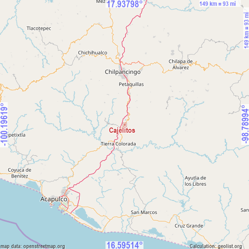
Cajelitos GPS coordinates[2]
17° 16' 4.008" North, 99° 29' 35.016" West
| Map corner | latitude | longitude |
|---|---|---|
| Upper-left | 17.93798°, | -100.19619° |
| Center: | 17.26778°, | -99.49306° |
| Lower-right: | 16.59514°, | -98.78994° |
| Map W x H: | 149.3×149.3 km | = 92.8×92.8mi |
| max Lat: | 32.7° ⇑85.7% North |
| Cajelitos: | 17.26778° |
| min Lat: | ⇓14.3% South 14.53588° |
| min Long | Cajelitos | max Long |
| -117.105° | -99.49306° | -86.73105° |
| W 43.1%⇐ | ⇒56.9% E |
Elevation
Elevation of Cajelitos is 718 m = 2356 ft, and this is 535.7 m = 1758 ft below average elevation for this country.
| Max E: |
3497 m = 11473 ft | 64.5% |
| Avg. | 1253.7 m = 4113 ft | |
| Cajelitos | 718 m = 2356 ft | |
Min E: |
-1 m = -3 ft | 35.5% |
See also: Mexico elevation on elevation.city.
Geographical zone
Cajelitos is located in North Torrid zone (between Equator and Tropic of Cancer). Distance of this Northern Tropic circle is 685.9 km =426.2 mi to North.| Distance of | km | miles | from Cajelitos |
|---|---|---|---|
| North Pole | 8087.1 | 5025.1 | to North |
| Arctic Circle | 5481.2 | 3405.9 | to North |
| Tropic Cancer | 685.9 | 426.2 | to North |
| Equator | 1920 | 1193 | to South |


Nearby cities:
15 places around Cajelitos: (largest is in red/bold)
• Acahuizotla
10.7 km =6.6 mi,  14°
14°
• Buena Vista de la Salud
1.2 km =0.7 mi,  230°
230°
• El Ocotito
3.4 km =2.1 mi,  224°
224°
• El Potrero Oriental
11.8 km =7.3 mi,  182°
182°
• El Puente
15.8 km =9.8 mi,  142°
142°
• Garrapatas (Garrapata)
9.2 km =5.7 mi,  197°
197°
• Julián Blanco (Dos Caminos)
6.4 km =4 mi,  211°
211°
• Mohoneras
4.4 km =2.7 mi, 213°
• Omitlán
16.8 km =10.4 mi,  185°
185°
• Palo Blanco
15.4 km =9.6 mi, 10°
• Palo Gordo
13.9 km =8.6 mi, 205°
• Tierra Colorada
11.9 km =7.4 mi, 198°
• Tlahuizapa
12.2 km =7.6 mi,  288°
288°
• Xolapa
17.5 km =10.9 mi, 227°
• Zoyatepec
9.6 km =6 mi,  315°
315°
Sources, notices
• [Note1] Compared only with cities in Mexico existing in our database
• [Src1] Map data: © OpenStreetMap contributors (CC-BY-SA)
• [Src2] Other city data from geonames.org with taken over terms of usage.
• [Src3] Geographical zone / Annual Mean Temperature by Robert A. Rohde @ Wikipedia
