Zoyatepec geodata
Zoyatepec (Guerrero) is a populated place; located in Mexico in America/Mexico_City (GMT-6) time zone. With population of 574 people, there are 14926 cities with bigger population in this country. Compared to other cities in Mexico, 85% of cities are located further ↑North; 57.7% of cities are located further →East and 64% of cities have higher elevation than Zoyatepec. Note1


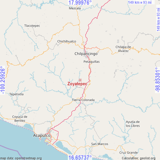
Zoyatepec GPS coordinates[2]
17° 19' 47.244" North, 99° 33' 22.068" West
| Map corner | latitude | longitude |
|---|---|---|
| Upper-left | 17.99976°, | -100.25926° |
| Center: | 17.32979°, | -99.55613° |
| Lower-right: | 16.65737°, | -98.85301° |
| Map W x H: | 149.3×149.3 km | = 92.8×92.8mi |
| max Lat: | 32.7° ⇑85% North |
| Zoyatepec: | 17.32979° |
| min Lat: | ⇓15% South 14.53588° |
| min Long | Zoyatepec | max Long |
| -117.105° | -99.55613° | -86.73105° |
| W 42.3%⇐ | ⇒57.7% E |
Elevation
Elevation of Zoyatepec is 753 m = 2470 ft, and this is 500.7 m = 1643 ft below average elevation for this country.
| Max E: |
3497 m = 11473 ft | 64% |
| Avg. | 1253.7 m = 4113 ft | |
| Zoyatepec | 753 m = 2470 ft | |
Min E: |
-1 m = -3 ft | 36% |
See also: Mexico elevation on elevation.city.
Geographical zone
Zoyatepec is located in North Torrid zone (between Equator and Tropic of Cancer). Distance of this Northern Tropic circle is 679 km =421.9 mi to North.| Distance of | km | miles | from Zoyatepec |
|---|---|---|---|
| North Pole | 8080.2 | 5020.8 | to North |
| Arctic Circle | 5474.3 | 3401.6 | to North |
| Tropic Cancer | 679 | 421.9 | to North |
| Equator | 1926.9 | 1197.3 | to South |


Nearby cities:
15 places around Zoyatepec: (largest is in red/bold)
• Acahuizotla
10 km =6.2 mi,  70°
70°
• Buena Vista de la Salud
9.6 km =6 mi,  143°
143°
• Cajelitos
9.6 km =6 mi, 135°
• Coacoyulillo
9.8 km =6.1 mi,  273°
273°
• El Fresno
11.7 km =7.3 mi,  344°
344°
• El Ocotito
10.3 km =6.4 mi,  155°
155°
• Garrapatas (Garrapata)
16.2 km =10.1 mi,  165°
165°
• Inscuinatoyac (El Pueblito)
18.9 km =11.7 mi,  282°
282°
• Julián Blanco (Dos Caminos)
12.8 km =8 mi, 164°
• La Esperanza
8.6 km =5.3 mi,  319°
319°
• Mazatlán
15.3 km =9.5 mi,  39°
39°
• Mohoneras
11.4 km =7.1 mi, 158°
• Palo Blanco
12.6 km =7.8 mi,  49°
49°
• Tierra Colorada
18.5 km =11.5 mi, 170°
• Tlahuizapa
5.7 km =3.5 mi,  238°
238°
Sources, notices
• [Note1] Compared only with cities in Mexico existing in our database
• [Src1] Map data: © OpenStreetMap contributors (CC-BY-SA)
• [Src2] Other city data from geonames.org with taken over terms of usage.
• [Src3] Geographical zone / Annual Mean Temperature by Robert A. Rohde @ Wikipedia
