Garrapatas (Garrapata) geodata
Garrapatas (Garrapata) (Guerrero) is a populated place; located in Mexico in America/Mexico_City (GMT-6) time zone. With population of 762 people, there are 11496 cities with bigger population in this country. Compared to other cities in Mexico, 86.7% of cities are located further ↑North; 57.2% of cities are located further →East and 68.9% of cities have higher elevation than Garrapatas (Garrapata). Note1


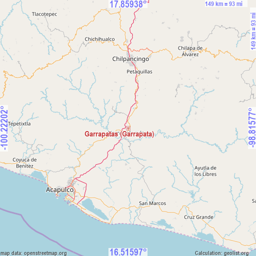
Garrapatas (Garrapata) GPS coordinates[2]
17° 11' 20.004" North, 99° 31' 8.004" West
| Map corner | latitude | longitude |
|---|---|---|
| Upper-left | 17.85938°, | -100.22202° |
| Center: | 17.18889°, | -99.51889° |
| Lower-right: | 16.51597°, | -98.81577° |
| Map W x H: | 149.4×149.4 km | = 92.8×92.8mi |
| max Lat: | 32.7° ⇑86.7% North |
| Garrapatas (Garrapata): | 17.18889° |
| min Lat: | ⇓13.3% South 14.53588° |
| min Long | Garrapatas (Gar | max Long |
| -117.105° | -99.51889° | -86.73105° |
| W 42.8%⇐ | ⇒57.2% E |
Elevation
Elevation of Garrapatas (Garrapata) is 472 m = 1549 ft, and this is 781.7 m = 2565 ft below average elevation for this country.
| Max E: |
3497 m = 11473 ft | 68.9% |
| Avg. | 1253.7 m = 4113 ft | |
| Garrapatas (Garrapata) | 472 m = 1549 ft | |
Min E: |
-1 m = -3 ft | 31.1% |
See also: Mexico elevation on elevation.city.
Geographical zone
Garrapatas (Garrapata) is located in North Torrid zone (between Equator and Tropic of Cancer). Distance of this Northern Tropic circle is 694.7 km =431.7 mi to North.| Distance of | km | miles | from Garrapatas (Garrapata) |
|---|---|---|---|
| North Pole | 8095.8 | 5030.5 | to North |
| Arctic Circle | 5489.9 | 3411.3 | to North |
| Tropic Cancer | 694.7 | 431.7 | to North |
| Equator | 1911.2 | 1187.6 | to South |


Nearby cities:
15 places around Garrapatas (Garrapata): (largest is in red/bold)
• Buena Vista de la Salud
8.2 km =5.1 mi,  12°
12°
• Cajelitos
9.2 km =5.7 mi,  17°
17°
• El Ocotito
6.4 km =4 mi,  3°
3°
• El Potrero Oriental
3.8 km =2.4 mi,  142°
142°
• El Puente
12.9 km =8 mi,  106°
106°
• Julián Blanco (Dos Caminos)
3.4 km =2.1 mi,  349°
349°
• La Palma
12 km =7.5 mi,  175°
175°
• Mohoneras
5.1 km =3.2 mi, 3°
• Omitlán
8.1 km =5 mi,  171°
171°
• Palo Gordo
4.9 km =3 mi,  219°
219°
• Rancho Viejo
16.4 km =10.2 mi,  129°
129°
• Tierra Colorada
2.7 km =1.7 mi,  200°
200°
• Tlahuizapa
15.5 km =9.6 mi,  325°
325°
• Xolapa
10.6 km =6.6 mi,  252°
252°
• Zoyatepec
16.2 km =10.1 mi, 345°
Sources, notices
• [Note1] Compared only with cities in Mexico existing in our database
• [Src1] Map data: © OpenStreetMap contributors (CC-BY-SA)
• [Src2] Other city data from geonames.org with taken over terms of usage.
• [Src3] Geographical zone / Annual Mean Temperature by Robert A. Rohde @ Wikipedia
