Jolochero 2da. Sección geodata
Jolochero 2da. Sección (Tabasco) is a populated place; located in Mexico in America/Mexico_City (GMT-6) time zone. With population of 1,303 people, there are 6657 cities with bigger population in this country. Compared to other cities in Mexico, 77.3% of cities are located further ↑North; 89.9% of cities are located further ←West and 99.6% of cities have higher elevation than Jolochero 2da. Sección. Note1
Current local time in Jolochero 2da. Sección:
08:32 AM, WednesdayDifference from your time zone: hours


Jolochero 2da. Sección GPS coordinates[2]
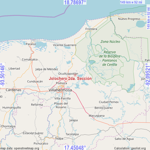
18° 7' 12" North, 92° 47' 53.988" West
| Map corner | latitude | longitude |
|---|---|---|
| Upper-left | 18.78697°, | -93.50146° |
| Center: | 18.12°, | -92.79833° |
| Lower-right: | 17.45048°, | -92.09521° |
| Map W x H: | 148.6×148.6 km | = 92.3×92.3mi |
| max Lat: | 32.7° ⇑77.3% North |
| Jolochero 2da. Sección: | 18.12° |
| min Lat: | ⇓22.7% South 14.53588° |
| min Long | Jolochero 2da. | max Long |
| -117.105° | -92.79833° | -86.73105° |
| W 89.9%⇐ | ⇒10.1% E |
Elevation
Elevation of Jolochero 2da. Sección is 4 m = 13 ft, and this is 1249.7 m = 4100 ft below average elevation for this country.
| Max E: |
3497 m = 11473 ft | 99.6% |
| Avg. | 1253.7 m = 4113 ft | |
| Jolochero 2da. Sección | 4 m = 13 ft | |
Min E: |
-1 m = -3 ft | 0.4% |
See also: Mexico elevation on elevation.city.
Geographical zone
Jolochero 2da. Sección is located in North Torrid zone (between Equator and Tropic of Cancer). Distance of this Northern Tropic circle is 591.2 km =367.4 mi to North.| Distance of | km | miles | from Jolochero 2da. Sección |
|---|---|---|---|
| North Pole | 7992.3 | 4966.2 | to North |
| Arctic Circle | 5386.4 | 3347 | to North |
| Tropic Cancer | 591.2 | 367.4 | to North |
| Equator | 2014.8 | 1251.9 | to South |


Nearby cities:
15 places around Jolochero 2da. Sección: (largest is in red/bold)
• Acachapan y Colmena 2da. Sección (La Arena)
8.6 km =5.3 mi,  199°
199°
• Acachapan y Colmena 3ra. Sección
8.2 km =5.1 mi,  164°
164°
• Buena Vista 1ra. Sección
5.8 km =3.6 mi,  62°
62°
• El Alambrado
4.7 km =2.9 mi,  9°
9°
• Fraccionamiento Ocuiltzapotlán Dos
7.4 km =4.6 mi,  260°
260°
• Francisco I. Madero 1ra. Sección
5.4 km =3.4 mi,  268°
268°
• La Ceiba
3.5 km =2.2 mi,  38°
38°
• La Loma
5.5 km =3.4 mi,  351°
351°
• La Manga
4.4 km =2.7 mi,  51°
51°
• Macultepec
7.4 km =4.6 mi,  296°
296°
• Medellín y Madero Segunda Sección
5.9 km =3.7 mi, 263°
• Miramar
4.3 km =2.7 mi,  67°
67°
• Paso Real de la Victoria
8.3 km =5.2 mi,  283°
283°
• Rovirosa
5.5 km =3.4 mi, 37°
• Tamulte de las Sabanas
4.9 km =3 mi,  18°
18°
Sources, notices
• [Note1] Compared only with cities in Mexico existing in our database
• [Src1] Map data: © OpenStreetMap contributors (CC-BY-SA)
• [Src2] Other city data from geonames.org with taken over terms of usage.
• [Src3] Geographical zone / Annual Mean Temperature by Robert A. Rohde @ Wikipedia
