La Sábana geodata
La Sábana (Tabasco) is a populated place; located in Mexico in America/Mexico_City (GMT-6) time zone. With population of 1,193 people, there are 7278 cities with bigger population in this country. Compared to other cities in Mexico, 73.2% of cities are located further ↑North; 89.3% of cities are located further ←West and 99.1% of cities have higher elevation than La Sábana. Note1


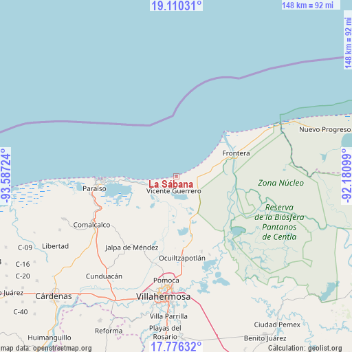
La Sábana GPS coordinates[2]
18° 26' 40.596" North, 92° 53' 2.796" West
| Map corner | latitude | longitude |
|---|---|---|
| Upper-left | 19.11031°, | -93.58724° |
| Center: | 18.44461°, | -92.88411° |
| Lower-right: | 17.77632°, | -92.18099° |
| Map W x H: | 148.3×148.3 km | = 92.1×92.1mi |
| max Lat: | 32.7° ⇑73.2% North |
| La Sábana: | 18.44461° |
| min Lat: | ⇓26.8% South 14.53588° |
| min Long | La Sábana | max Long |
| -117.105° | -92.88411° | -86.73105° |
| W 89.3%⇐ | ⇒10.7% E |
Elevation
Elevation of La Sábana is 6 m = 20 ft, and this is 1247.7 m = 4094 ft below average elevation for this country.
| Max E: |
3497 m = 11473 ft | 99.1% |
| Avg. | 1253.7 m = 4113 ft | |
| La Sábana | 6 m = 20 ft | |
Min E: |
-1 m = -3 ft | 0.9% |
See also: Mexico elevation on elevation.city.
Geographical zone
La Sábana is located in North Torrid zone (between Equator and Tropic of Cancer). Distance of this Northern Tropic circle is 555.1 km =344.9 mi to North.| Distance of | km | miles | from La Sábana |
|---|---|---|---|
| North Pole | 7956.2 | 4943.8 | to North |
| Arctic Circle | 5350.3 | 3324.5 | to North |
| Tropic Cancer | 555.1 | 344.9 | to North |
| Equator | 2050.8 | 1274.3 | to South |


Nearby cities:
15 places around La Sábana: (largest is in red/bold)
• Adolfo López Mateos
7.9 km =4.9 mi,  245°
245°
• Benito Juárez
8.8 km =5.5 mi,  103°
103°
• Constancia y Venecia
6.5 km =4 mi, 98°
• Ejido Benito Juárez
6.9 km =4.3 mi,  84°
84°
• Francisco Villa
4.5 km =2.8 mi,  174°
174°
• Frontera
6.7 km =4.2 mi,  116°
116°
• Gobernador Cruz
1.8 km =1.1 mi,  133°
133°
• Gregorio Méndez Magaña
3.2 km =2 mi,  183°
183°
• Ignacio Allende
8 km =5 mi,  148°
148°
• Ignacio Zaragoza
9.3 km =5.8 mi,  238°
238°
• José María Morelos y Pavón
4.9 km =3 mi, 131°
• La Pimienta
1.9 km =1.2 mi,  197°
197°
• La Unión
3.6 km =2.2 mi, 176°
• Lázaro Cárdenas
8.9 km =5.5 mi, 246°
• Villa Vicente Guerrero
6.2 km =3.9 mi,  191°
191°
Sources, notices
• [Note1] Compared only with cities in Mexico existing in our database
• [Src1] Map data: © OpenStreetMap contributors (CC-BY-SA)
• [Src2] Other city data from geonames.org with taken over terms of usage.
• [Src3] Geographical zone / Annual Mean Temperature by Robert A. Rohde @ Wikipedia
