Gobernador Cruz geodata
Gobernador Cruz (Tabasco) is a populated place; located in Mexico in America/Mexico_City (GMT-6) time zone. With population of 1,629 people, there are 5313 cities with bigger population in this country. Compared to other cities in Mexico, 73.3% of cities are located further ↑North; 89.4% of cities are located further ←West and 98.1% of cities have higher elevation than Gobernador Cruz. Note1


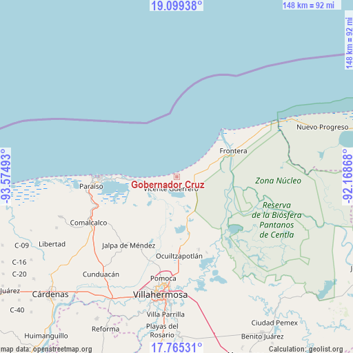
Gobernador Cruz GPS coordinates[2]
18° 26' 1.104" North, 92° 52' 18.48" West
| Map corner | latitude | longitude |
|---|---|---|
| Upper-left | 19.09938°, | -93.57493° |
| Center: | 18.43364°, | -92.8718° |
| Lower-right: | 17.76531°, | -92.16868° |
| Map W x H: | 148.3×148.3 km | = 92.1×92.1mi |
| max Lat: | 32.7° ⇑73.3% North |
| Gobernador Cruz: | 18.43364° |
| min Lat: | ⇓26.7% South 14.53588° |
| min Long | Gobernador Cruz | max Long |
| -117.105° | -92.8718° | -86.73105° |
| W 89.4%⇐ | ⇒10.6% E |
Elevation
Elevation of Gobernador Cruz is 8 m = 26 ft, and this is 1245.7 m = 4087 ft below average elevation for this country.
| Max E: |
3497 m = 11473 ft | 98.1% |
| Avg. | 1253.7 m = 4113 ft | |
| Gobernador Cruz | 8 m = 26 ft | |
Min E: |
-1 m = -3 ft | 1.9% |
See also: Mexico elevation on elevation.city.
Geographical zone
Gobernador Cruz is located in North Torrid zone (between Equator and Tropic of Cancer). Distance of this Northern Tropic circle is 556.3 km =345.7 mi to North.| Distance of | km | miles | from Gobernador Cruz |
|---|---|---|---|
| North Pole | 7957.4 | 4944.5 | to North |
| Arctic Circle | 5351.5 | 3325.3 | to North |
| Tropic Cancer | 556.3 | 345.7 | to North |
| Equator | 2049.6 | 1273.6 | to South |


Nearby cities:
15 places around Gobernador Cruz: (largest is in red/bold)
• Adolfo López Mateos
8.7 km =5.4 mi,  256°
256°
• Benito Juárez
7.3 km =4.5 mi,  96°
96°
• Constancia y Venecia
5.1 km =3.2 mi,  87°
87°
• Ejido Benito Juárez
5.9 km =3.7 mi,  70°
70°
• Francisco Villa
3.4 km =2.1 mi,  194°
194°
• Frontera
5 km =3.1 mi,  110°
110°
• Gregorio Méndez Magaña
2.5 km =1.6 mi,  217°
217°
• Ignacio Allende
6.3 km =3.9 mi,  152°
152°
• José María Morelos y Pavón
3.1 km =1.9 mi,  130°
130°
• La Pimienta
2 km =1.2 mi,  252°
252°
• La Sábana
1.8 km =1.1 mi,  313°
313°
• La Unión
2.7 km =1.7 mi,  204°
204°
• San José del Carmen
8.9 km =5.5 mi, 99°
• Villa Vicente Guerrero
5.5 km =3.4 mi,  207°
207°
• Álvaro Obregón (Santa Cruz)
8.8 km =5.5 mi,  119°
119°
Sources, notices
• [Note1] Compared only with cities in Mexico existing in our database
• [Src1] Map data: © OpenStreetMap contributors (CC-BY-SA)
• [Src2] Other city data from geonames.org with taken over terms of usage.
• [Src3] Geographical zone / Annual Mean Temperature by Robert A. Rohde @ Wikipedia
