José María Morelos y Pavón geodata
José María Morelos y Pavón (Tabasco) is a populated place; located in Mexico in America/Mexico_City (GMT-6) time zone. With population of 592 people, there are 14508 cities with bigger population in this country. Compared to other cities in Mexico, 73.6% of cities are located further ↑North; 89.5% of cities are located further ←West and 98.7% of cities have higher elevation than José María Morelos y Pavón. Note1
Current local time in José María Morelos y Pavón:
10:24 AM, MondayDifference from your time zone: hours


José María Morelos y Pavón GPS coordinates[2]
18° 24' 55.512" North, 92° 50' 56.292" West
| Map corner | latitude | longitude |
|---|---|---|
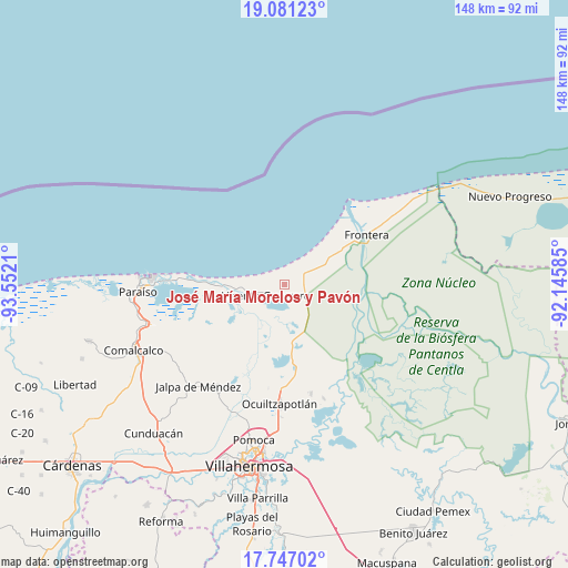
| Upper-left | 19.08123°, | -93.5521° |
| Center: | 18.41542°, | -92.84897° |
| Lower-right: | 17.74702°, | -92.14585° |
| Map W x H: | 148.4×148.4 km | = 92.2×92.2mi |
| max Lat: | 32.7° ⇑73.6% North |
| José María Morelos y Pavón: | 18.41542° |
| min Lat: | ⇓26.4% South 14.53588° |
| min Long | José María Mo | max Long |
| -117.105° | -92.84897° | -86.73105° |
| W 89.5%⇐ | ⇒10.5% E |
Elevation
Elevation of José María Morelos y Pavón is 7 m = 23 ft, and this is 1246.7 m = 4090 ft below average elevation for this country.
| Max E: |
3497 m = 11473 ft | 98.7% |
| Avg. | 1253.7 m = 4113 ft | |
| José María Morelos y Pavón | 7 m = 23 ft | |
Min E: |
-1 m = -3 ft | 1.3% |
See also: Mexico elevation on elevation.city.
Geographical zone
José María Morelos y Pavón is located in North Torrid zone (between Equator and Tropic of Cancer). Distance of this Northern Tropic circle is 558.3 km =346.9 mi to North.| Distance of | km | miles | from José María Morelos y Pavón |
|---|---|---|---|
| North Pole | 7959.5 | 4945.8 | to North |
| Arctic Circle | 5353.6 | 3326.6 | to North |
| Tropic Cancer | 558.3 | 346.9 | to North |
| Equator | 2047.6 | 1272.3 | to South |


Nearby cities:
15 places around José María Morelos y Pavón: (largest is in red/bold)
• Benito Juárez
5 km =3.1 mi,  76°
76°
• Constancia y Venecia
3.5 km =2.2 mi,  50°
50°
• Ejido Benito Juárez
5.1 km =3.2 mi,  38°
38°
• Francisco Villa
3.5 km =2.2 mi,  249°
249°
• Frontera
2.3 km =1.4 mi, 83°
• Gobernador Cruz
3.1 km =1.9 mi,  310°
310°
• Gregorio Méndez Magaña
3.9 km =2.4 mi,  270°
270°
• Ignacio Allende
3.6 km =2.2 mi,  172°
172°
• La Pimienta
4.5 km =2.8 mi,  288°
288°
• La Sábana
4.9 km =3 mi, 311°
• La Unión
3.5 km =2.2 mi,  263°
263°
• San José del Carmen
6.4 km =4 mi, 84°
• Villa Vicente Guerrero
5.7 km =3.5 mi,  240°
240°
• Álvaro Obregón (Santa Cruz)
5.7 km =3.5 mi,  114°
114°
• Álvaro Obregón 2da. Sección (El Lechugal)
6.6 km =4.1 mi, 112°
Sources, notices
• [Note1] Compared only with cities in Mexico existing in our database
• [Src1] Map data: © OpenStreetMap contributors (CC-BY-SA)
• [Src2] Other city data from geonames.org with taken over terms of usage.
• [Src3] Geographical zone / Annual Mean Temperature by Robert A. Rohde @ Wikipedia
