Estación la Piedad geodata
Estación la Piedad (Guanajuato) is a populated place; located in Mexico in America/Mexico_City (GMT-6) time zone. With population of 1,123 people, there are 7722 cities with bigger population in this country. Compared to other cities in Mexico, 64.9% of cities are located further ↓South; 80.9% of cities are located further →East and 57.6% of cities have lower elevation than Estación la Piedad. Note1


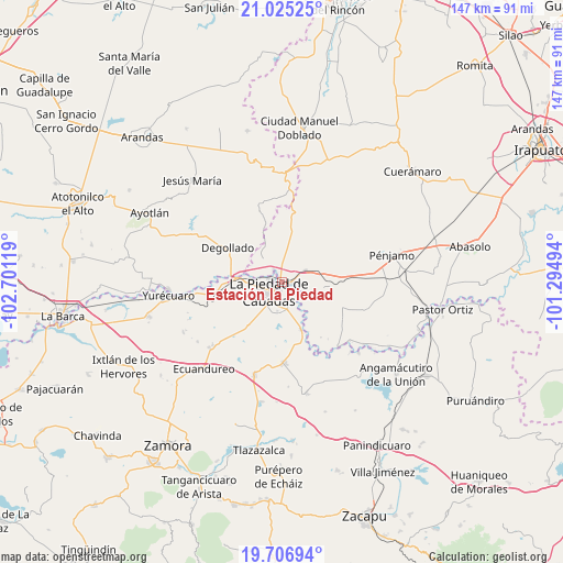
Estación la Piedad GPS coordinates[2]
20° 22' 3" North, 101° 59' 53.016" West
| Map corner | latitude | longitude |
|---|---|---|
| Upper-left | 21.02525°, | -102.70119° |
| Center: | 20.3675°, | -101.99806° |
| Lower-right: | 19.70694°, | -101.29494° |
| Map W x H: | 146.6×146.6 km | = 91.1×91.1mi |
| max Lat: | 32.7° ⇑35.1% North |
| Estación la Piedad: | 20.3675° |
| min Lat: | ⇓64.9% South 14.53588° |
| min Long | Estación la Pi | max Long |
| -117.105° | -101.99806° | -86.73105° |
| W 19.1%⇐ | ⇒80.9% E |
Elevation
Elevation of Estación la Piedad is 1681 m = 5515 ft, and this is 427.3 m = 1402 ft above average elevation for this country.
| Max E: |
3497 m = 11473 ft | 42.4% |
| Estación la Piedad | 1681 m 5515 ft | |
| Avg. | 1253.7 m = 4113 ft | |
Min E: |
-1 m = -3 ft | 57.6% |
See also: Mexico elevation on elevation.city.
Geographical zone
Estación la Piedad is located in North Torrid zone (between Equator and Tropic of Cancer). Distance of this Northern Tropic circle is 341.3 km =212.1 mi to North.| Distance of | km | miles | from Estación la Piedad |
|---|---|---|---|
| North Pole | 7742.4 | 4810.9 | to North |
| Arctic Circle | 5136.5 | 3191.7 | to North |
| Tropic Cancer | 341.3 | 212.1 | to North |
| Equator | 2264.7 | 1407.2 | to South |


Nearby cities:
15 places around Estación la Piedad: (largest is in red/bold)
• El Fuerte
7.2 km =4.5 mi,  274°
274°
• Guanajuatillo
3.5 km =2.2 mi,  181°
181°
• Guayabito de Pedroza
3.3 km =2.1 mi,  72°
72°
• La Cal Grande
6.2 km =3.9 mi,  115°
115°
• La Ermita
5.4 km =3.4 mi,  7°
7°
• La Piedad
4.4 km =2.7 mi,  230°
230°
• La Sarna
3.9 km =2.4 mi,  54°
54°
• Laguna Larga de Cortés
6.6 km =4.1 mi,  64°
64°
• Liebres de Suárez
4.8 km =3 mi,  359°
359°
• Los Ocotes
6.6 km =4.1 mi,  35°
35°
• Quesera de Cortés
4 km =2.5 mi,  326°
326°
• Río Grande
2.7 km =1.7 mi,  196°
196°
• Santa Ana Pacueco
2.9 km =1.8 mi,  219°
219°
• Villas de las Lomas
7.7 km =4.8 mi,  173°
173°
• Zaragoza
4.5 km =2.8 mi,  126°
126°
Sources, notices
• [Note1] Compared only with cities in Mexico existing in our database
• [Src1] Map data: © OpenStreetMap contributors (CC-BY-SA)
• [Src2] Other city data from geonames.org with taken over terms of usage.
• [Src3] Geographical zone / Annual Mean Temperature by Robert A. Rohde @ Wikipedia
