Zaragoza geodata
Zaragoza (Michoacán) is a populated place; located in Mexico in America/Mexico_City (GMT-6) time zone. With population of 794 people, there are 10982 cities with bigger population in this country. Compared to other cities in Mexico, 64.4% of cities are located further ↓South; 80.7% of cities are located further →East and 57.8% of cities have lower elevation than Zaragoza. Note1


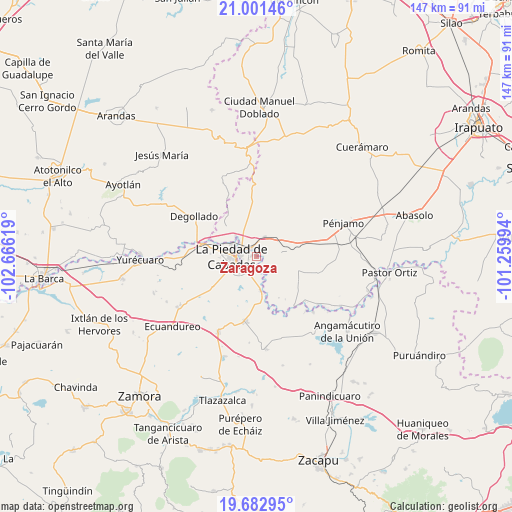
Zaragoza GPS coordinates[2]
20° 20' 36.996" North, 101° 57' 47.016" West
| Map corner | latitude | longitude |
|---|---|---|
| Upper-left | 21.00146°, | -102.66619° |
| Center: | 20.34361°, | -101.96306° |
| Lower-right: | 19.68295°, | -101.25994° |
| Map W x H: | 146.6×146.6 km | = 91.1×91.1mi |
| max Lat: | 32.7° ⇑35.6% North |
| Zaragoza: | 20.34361° |
| min Lat: | ⇓64.4% South 14.53588° |
| min Long | Zaragoza | max Long |
| -117.105° | -101.96306° | -86.73105° |
| W 19.3%⇐ | ⇒80.7% E |
Elevation
Elevation of Zaragoza is 1686 m = 5531 ft, and this is 432.3 m = 1418 ft above average elevation for this country.
| Max E: |
3497 m = 11473 ft | 42.2% |
| Zaragoza | 1686 m 5531 ft | |
| Avg. | 1253.7 m = 4113 ft | |
Min E: |
-1 m = -3 ft | 57.8% |
See also: Mexico elevation on elevation.city.
Geographical zone
Zaragoza is located in North Torrid zone (between Equator and Tropic of Cancer). Distance of this Northern Tropic circle is 343.9 km =213.7 mi to North.| Distance of | km | miles | from Zaragoza |
|---|---|---|---|
| North Pole | 7745.1 | 4812.6 | to North |
| Arctic Circle | 5139.2 | 3193.3 | to North |
| Tropic Cancer | 343.9 | 213.7 | to North |
| Equator | 2262 | 1405.5 | to South |


Nearby cities:
15 places around Zaragoza: (largest is in red/bold)
• Cañada de Ramírez
5.3 km =3.3 mi,  180°
180°
• Colonia Morelos
7.2 km =4.5 mi,  67°
67°
• Estación la Piedad
4.5 km =2.8 mi,  306°
306°
• Guanajuatillo
3.8 km =2.4 mi,  257°
257°
• Guayabito de Pedroza
3.7 km =2.3 mi,  352°
352°
• La Cal Grande
2 km =1.2 mi,  89°
89°
• La Estancia del Refugio
6.2 km =3.9 mi,  148°
148°
• La Estrella
6.8 km =4.2 mi,  40°
40°
• La Piedad
7 km =4.3 mi,  268°
268°
• La Sarna
4.9 km =3 mi, 354°
• Laguna Larga de Cortés
5.9 km =3.7 mi,  23°
23°
• Las Cañadas
5.4 km =3.4 mi,  196°
196°
• Río Grande
4.4 km =2.7 mi, 270°
• Santa Ana Pacueco
5.5 km =3.4 mi, 274°
• Villas de las Lomas
5.7 km =3.5 mi,  208°
208°
Sources, notices
• [Note1] Compared only with cities in Mexico existing in our database
• [Src1] Map data: © OpenStreetMap contributors (CC-BY-SA)
• [Src2] Other city data from geonames.org with taken over terms of usage.
• [Src3] Geographical zone / Annual Mean Temperature by Robert A. Rohde @ Wikipedia
