La Sarna geodata
La Sarna (Guanajuato) is a populated place; located in Mexico in America/Mexico_City (GMT-6) time zone. With population of 516 people, there are 16314 cities with bigger population in this country. Compared to other cities in Mexico, 65.3% of cities are located further ↓South; 80.7% of cities are located further →East and 58.3% of cities have lower elevation than La Sarna. Note1


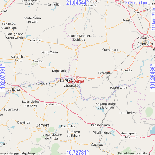
La Sarna GPS coordinates[2]
20° 23' 16.008" North, 101° 58' 4.008" West
| Map corner | latitude | longitude |
|---|---|---|
| Upper-left | 21.04544°, | -102.67091° |
| Center: | 20.38778°, | -101.96778° |
| Lower-right: | 19.72731°, | -101.26466° |
| Map W x H: | 146.6×146.6 km | = 91.1×91.1mi |
| max Lat: | 32.7° ⇑34.7% North |
| La Sarna: | 20.38778° |
| min Lat: | ⇓65.3% South 14.53588° |
| min Long | La Sarna | max Long |
| -117.105° | -101.96778° | -86.73105° |
| W 19.3%⇐ | ⇒80.7% E |
Elevation
Elevation of La Sarna is 1695 m = 5561 ft, and this is 441.3 m = 1448 ft above average elevation for this country.
| Max E: |
3497 m = 11473 ft | 41.7% |
| La Sarna | 1695 m 5561 ft | |
| Avg. | 1253.7 m = 4113 ft | |
Min E: |
-1 m = -3 ft | 58.3% |
See also: Mexico elevation on elevation.city.
Geographical zone
La Sarna is located in North Torrid zone (between Equator and Tropic of Cancer). Distance of this Northern Tropic circle is 339 km =210.6 mi to North.| Distance of | km | miles | from La Sarna |
|---|---|---|---|
| North Pole | 7740.2 | 4809.5 | to North |
| Arctic Circle | 5134.3 | 3190.3 | to North |
| Tropic Cancer | 339 | 210.6 | to North |
| Equator | 2266.9 | 1408.6 | to South |


Nearby cities:
15 places around La Sarna: (largest is in red/bold)
• Estación la Piedad
3.9 km =2.4 mi,  234°
234°
• Guanajuatillo
6.6 km =4.1 mi,  209°
209°
• Guayabito de Pedroza
1.3 km =0.8 mi,  180°
180°
• La Cal Grande
5.5 km =3.4 mi,  153°
153°
• La Ermita
3.9 km =2.4 mi,  322°
322°
• La Estrella
4.9 km =3 mi,  86°
86°
• La Madeja
6 km =3.7 mi,  22°
22°
• Laguna Larga de Cortés
2.9 km =1.8 mi,  79°
79°
• Liebres de Suárez
4.1 km =2.5 mi,  309°
309°
• Los Ocotes
3.2 km =2 mi,  12°
12°
• Quesera de Cortés
5.5 km =3.4 mi,  281°
281°
• Río Grande
6.2 km =3.9 mi,  219°
219°
• San Rafael de la Maraña
6.8 km =4.2 mi, 85°
• Santa Ana Pacueco
6.7 km =4.2 mi, 227°
• Zaragoza
4.9 km =3 mi,  174°
174°
Sources, notices
• [Note1] Compared only with cities in Mexico existing in our database
• [Src1] Map data: © OpenStreetMap contributors (CC-BY-SA)
• [Src2] Other city data from geonames.org with taken over terms of usage.
• [Src3] Geographical zone / Annual Mean Temperature by Robert A. Rohde @ Wikipedia
