Santiago Tlacochcalco geodata
Santiago Tlacochcalco (Tlaxcala) is a populated place; located in Mexico in America/Mexico_City (GMT-6) time zone. With population of 1,082 people, there are 8049 cities with bigger population in this country. Compared to other cities in Mexico, 59.4% of cities are located further ↑North; 60.9% of cities are located further ←West and 86.1% of cities have lower elevation than Santiago Tlacochcalco. Note1


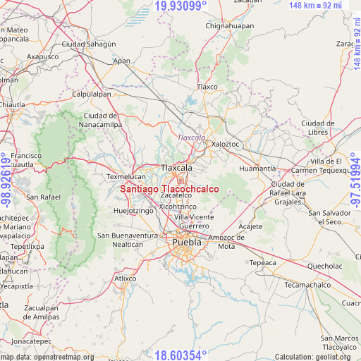
Santiago Tlacochcalco GPS coordinates[2]
19° 16' 6.996" North, 98° 13' 23.016" West
| Map corner | latitude | longitude |
|---|---|---|
| Upper-left | 19.93099°, | -98.92619° |
| Center: | 19.26861°, | -98.22306° |
| Lower-right: | 18.60354°, | -97.51994° |
| Map W x H: | 147.6×147.6 km | = 91.7×91.7mi |
| max Lat: | 32.7° ⇑59.4% North |
| Santiago Tlacochcalco: | 19.26861° |
| min Lat: | ⇓40.6% South 14.53588° |
| min Long | Santiago Tlacoc | max Long |
| -117.105° | -98.22306° | -86.73105° |
| W 60.9%⇐ | ⇒39.1% E |
Elevation
Elevation of Santiago Tlacochcalco is 2285 m = 7497 ft, and this is 1031.3 m = 3384 ft above average elevation for this country.
| Max E: |
3497 m = 11473 ft | 13.9% |
| Santiago Tlacochcalco | 2285 m 7497 ft | |
| Avg. | 1253.7 m = 4113 ft | |
Min E: |
-1 m = -3 ft | 86.1% |
See also: Mexico elevation on elevation.city.
Geographical zone
Santiago Tlacochcalco is located in North Torrid zone (between Equator and Tropic of Cancer). Distance of this Northern Tropic circle is 463.5 km =288 mi to North.| Distance of | km | miles | from Santiago Tlacochcalco |
|---|---|---|---|
| North Pole | 7864.6 | 4886.8 | to North |
| Arctic Circle | 5258.7 | 3267.6 | to North |
| Tropic Cancer | 463.5 | 288 | to North |
| Equator | 2142.5 | 1331.3 | to South |


Nearby cities:
15 places around Santiago Tlacochcalco: (largest is in red/bold)
• Acuamanala
5.5 km =3.4 mi,  154°
154°
• Acuitlapilco
1.4 km =0.9 mi,  292°
292°
• El Carmen Aztama
4.3 km =2.7 mi,  174°
174°
• La Aurora
1.3 km =0.8 mi,  180°
180°
• La Magdalena Tlaltelulco
3.2 km =2 mi,  60°
60°
• San Cosme Atlamaxac
3.4 km =2.1 mi, 183°
• San Jerónimo Zacualpan
5.1 km =3.2 mi,  232°
232°
• San Juan Huactzinco
5 km =3.1 mi,  218°
218°
• San Lorenzo Axocomanitla
5.6 km =3.5 mi,  208°
208°
• San Pedro Xalcaltzinco
4.6 km =2.9 mi,  186°
186°
• Santa Ana Chiautempan
5.6 km =3.5 mi,  41°
41°
• Santa Cruz Tetela
3.1 km =1.9 mi,  31°
31°
• Santa Isabel Xiloxoxtla
1 km =0.6 mi,  95°
95°
• Teolocholco
4.4 km =2.7 mi,  129°
129°
• Tepeyanco
2.8 km =1.7 mi,  204°
204°
Sources, notices
• [Note1] Compared only with cities in Mexico existing in our database
• [Src1] Map data: © OpenStreetMap contributors (CC-BY-SA)
• [Src2] Other city data from geonames.org with taken over terms of usage.
• [Src3] Geographical zone / Annual Mean Temperature by Robert A. Rohde @ Wikipedia
