Tepeyanco geodata
Tepeyanco (Tlaxcala) is a seat of a second-order administrative division; located in Mexico in America/Mexico_City (GMT-6) time zone. With population of 3,223 people, there are 2811 cities with bigger population in this country. Compared to other cities in Mexico, 60% of cities are located further ↑North; 60.7% of cities are located further ←West and 84% of cities have lower elevation than Tepeyanco. Note1


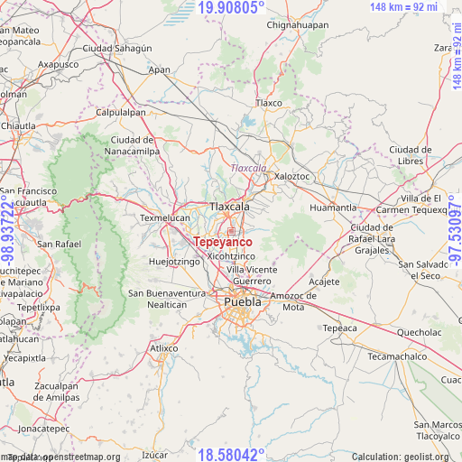
Tepeyanco GPS coordinates[2]
19° 14' 44.088" North, 98° 14' 2.724" West
| Map corner | latitude | longitude |
|---|---|---|
| Upper-left | 19.90805°, | -98.93722° |
| Center: | 19.24558°, | -98.23409° |
| Lower-right: | 18.58042°, | -97.53097° |
| Map W x H: | 147.6×147.6 km | = 91.7×91.7mi |
| max Lat: | 32.7° ⇑60% North |
| Tepeyanco: | 19.24558° |
| min Lat: | ⇓40% South 14.53588° |
| min Long | Tepeyanco | max Long |
| -117.105° | -98.23409° | -86.73105° |
| W 60.7%⇐ | ⇒39.3% E |
Elevation
Elevation of Tepeyanco is 2243 m = 7359 ft, and this is 989.3 m = 3246 ft above average elevation for this country.
| Max E: |
3497 m = 11473 ft | 16% |
| Tepeyanco | 2243 m 7359 ft | |
| Avg. | 1253.7 m = 4113 ft | |
Min E: |
-1 m = -3 ft | 84% |
See also: Mexico elevation on elevation.city.
Geographical zone
Tepeyanco is located in North Torrid zone (between Equator and Tropic of Cancer). Distance of this Northern Tropic circle is 466 km =289.6 mi to North.| Distance of | km | miles | from Tepeyanco |
|---|---|---|---|
| North Pole | 7867.2 | 4888.4 | to North |
| Arctic Circle | 5261.3 | 3269.2 | to North |
| Tropic Cancer | 466 | 289.6 | to North |
| Equator | 2139.9 | 1329.7 | to South |


Nearby cities:
15 places around Tepeyanco: (largest is in red/bold)
• Acuamanala
4.3 km =2.7 mi,  124°
124°
• Acuitlapilco
3.1 km =1.9 mi,  357°
357°
• Concepción Chimalpa
5 km =3.1 mi,  130°
130°
• El Carmen Aztama
2.3 km =1.4 mi,  138°
138°
• La Aurora
1.7 km =1.1 mi,  42°
42°
• San Cosme Atlamaxac
1.2 km =0.7 mi, 130°
• San Jerónimo Zacualpan
2.9 km =1.8 mi,  259°
259°
• San Juan Huactzinco
2.4 km =1.5 mi,  235°
235°
• San Lorenzo Axocomanitla
2.9 km =1.8 mi,  212°
212°
• San Pedro Xalcaltzinco
2.1 km =1.3 mi,  162°
162°
• Santa Cruz Quilehtla
3.6 km =2.2 mi, 159°
• Santa Isabel Xiloxoxtla
3.3 km =2.1 mi, 40°
• Santiago Tlacochcalco
2.8 km =1.7 mi,  24°
24°
• Teolocholco
4.5 km =2.8 mi,  93°
93°
• Zacatelco
3.4 km =2.1 mi,  190°
190°
Sources, notices
• [Note1] Compared only with cities in Mexico existing in our database
• [Src1] Map data: © OpenStreetMap contributors (CC-BY-SA)
• [Src2] Other city data from geonames.org with taken over terms of usage.
• [Src3] Geographical zone / Annual Mean Temperature by Robert A. Rohde @ Wikipedia
