San Jerónimo Zacualpan geodata
San Jerónimo Zacualpan (Tlaxcala) is a populated place; located in Mexico in America/Mexico_City (GMT-6) time zone. With population of 3,485 people, there are 2623 cities with bigger population in this country. Compared to other cities in Mexico, 60.1% of cities are located further ↑North; 60.4% of cities are located further ←West and 82.5% of cities have lower elevation than San Jerónimo Zacualpan. Note1
Current local time in San Jerónimo Zacualpan:
09:49 PM, TuesdayDifference from your time zone: hours


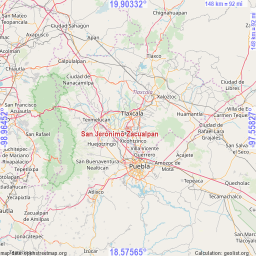
San Jerónimo Zacualpan GPS coordinates[2]
19° 14' 26.988" North, 98° 15' 41.004" West
| Map corner | latitude | longitude |
|---|---|---|
| Upper-left | 19.90332°, | -98.96452° |
| Center: | 19.24083°, | -98.26139° |
| Lower-right: | 18.57565°, | -97.55827° |
| Map W x H: | 147.6×147.6 km | = 91.7×91.7mi |
| max Lat: | 32.7° ⇑60.1% North |
| San Jerónimo Zacualpan: | 19.24083° |
| min Lat: | ⇓39.9% South 14.53588° |
| min Long | San Jerónimo Z | max Long |
| -117.105° | -98.26139° | -86.73105° |
| W 60.4%⇐ | ⇒39.6% E |
Elevation
Elevation of San Jerónimo Zacualpan is 2203 m = 7228 ft, and this is 949.3 m = 3115 ft above average elevation for this country.
| Max E: |
3497 m = 11473 ft | 17.5% |
| San Jerónimo Zacualpan | 2203 m 7228 ft | |
| Avg. | 1253.7 m = 4113 ft | |
Min E: |
-1 m = -3 ft | 82.5% |
See also: Mexico elevation on elevation.city.
Geographical zone
San Jerónimo Zacualpan is located in North Torrid zone (between Equator and Tropic of Cancer). Distance of this Northern Tropic circle is 466.5 km =289.9 mi to North.| Distance of | km | miles | from San Jerónimo Zacualpan |
|---|---|---|---|
| North Pole | 7867.7 | 4888.8 | to North |
| Arctic Circle | 5261.8 | 3269.5 | to North |
| Tropic Cancer | 466.5 | 289.9 | to North |
| Equator | 2139.4 | 1329.4 | to South |


Nearby cities:
15 places around San Jerónimo Zacualpan: (largest is in red/bold)
• Acuitlapilco
4.5 km =2.8 mi,  37°
37°
• El Carmen Aztama
4.6 km =2.9 mi,  105°
105°
• La Aurora
4.4 km =2.7 mi,  66°
66°
• San Bartolomé Tenango
3.4 km =2.1 mi,  292°
292°
• San Cosme Atlamaxac
3.8 km =2.4 mi,  94°
94°
• San Damián Texoloc
4.9 km =3 mi,  328°
328°
• San Juan Huactzinco
1.2 km =0.7 mi,  131°
131°
• San Lorenzo Axocomanitla
2.3 km =1.4 mi,  144°
144°
• San Pedro Xalcaltzinco
3.8 km =2.4 mi, 112°
• Santa Cruz Aquiahuac
2.2 km =1.4 mi,  265°
265°
• Santa Cruz Quilehtla
5 km =3.1 mi,  124°
124°
• Santiago Tlacochcalco
5.1 km =3.2 mi,  52°
52°
• Tepeyanco
2.9 km =1.8 mi,  79°
79°
• Tetlatlahuca
3.7 km =2.3 mi,  255°
255°
• Zacatelco
3.6 km =2.2 mi, 140°
Sources, notices
• [Note1] Compared only with cities in Mexico existing in our database
• [Src1] Map data: © OpenStreetMap contributors (CC-BY-SA)
• [Src2] Other city data from geonames.org with taken over terms of usage.
• [Src3] Geographical zone / Annual Mean Temperature by Robert A. Rohde @ Wikipedia
