Manzana la Cofradía geodata
Manzana la Cofradía (Michoacán) is a populated place; located in Mexico in America/Mexico_City (GMT-6) time zone. With population of 1,040 people, there are 8386 cities with bigger population in this country. Compared to other cities in Mexico, 53.1% of cities are located further ↑North; 68% of cities are located further →East and 86.6% of cities have lower elevation than Manzana la Cofradía. Note1


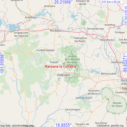
Manzana la Cofradía GPS coordinates[2]
19° 32' 57.984" North, 100° 21' 20.988" West
| Map corner | latitude | longitude |
|---|---|---|
| Upper-left | 20.21066°, | -101.05896° |
| Center: | 19.54944°, | -100.35583° |
| Lower-right: | 18.8855°, | -99.65271° |
| Map W x H: | 147.3×147.3 km | = 91.5×91.5mi |
| max Lat: | 32.7° ⇑53.1% North |
| Manzana la Cofradía: | 19.54944° |
| min Lat: | ⇓46.9% South 14.53588° |
| min Long | Manzana la Cofr | max Long |
| -117.105° | -100.35583° | -86.73105° |
| W 32%⇐ | ⇒68% E |
Elevation
Elevation of Manzana la Cofradía is 2297 m = 7536 ft, and this is 1043.3 m = 3423 ft above average elevation for this country.
| Max E: |
3497 m = 11473 ft | 13.4% |
| Manzana la Cofradía | 2297 m 7536 ft | |
| Avg. | 1253.7 m = 4113 ft | |
Min E: |
-1 m = -3 ft | 86.6% |
See also: Mexico elevation on elevation.city.
Geographical zone
Manzana la Cofradía is located in North Torrid zone (between Equator and Tropic of Cancer). Distance of this Northern Tropic circle is 432.2 km =268.6 mi to North.| Distance of | km | miles | from Manzana la Cofradía |
|---|---|---|---|
| North Pole | 7833.4 | 4867.4 | to North |
| Arctic Circle | 5227.5 | 3248.2 | to North |
| Tropic Cancer | 432.2 | 268.6 | to North |
| Equator | 2173.7 | 1350.7 | to South |


Nearby cities:
15 places around Manzana la Cofradía: (largest is in red/bold)
• Cieneguillas
6.4 km =4 mi,  58°
58°
• El Paso
0.8 km =0.5 mi,  354°
354°
• El Rincón de San Felipe (Tercera Manzana San Felipe)
5.1 km =3.2 mi,  200°
200°
• El Soldado Anónimo
5.8 km =3.6 mi,  11°
11°
• Jaripito (Jaripitio)
4.4 km =2.7 mi,  292°
292°
• La Manzana de Santa Cruz
1.1 km =0.7 mi,  213°
213°
• La Presa (Segunda Manzana Barrio de Santa Cruz)
5.9 km =3.7 mi,  246°
246°
• Macutzio
5.6 km =3.5 mi,  179°
179°
• Manzana el Mortero de San Cristóbal
2.1 km =1.3 mi,  29°
29°
• Mesa de los Alzati (Mesa de San Felipe)
6.6 km =4.1 mi, 212°
• Ocampo
4.1 km =2.5 mi, 25°
• Puentecillas (Tercera Manzana de Zirahuato)
7.1 km =4.4 mi,  226°
226°
• Rincón de Curungueo
7.4 km =4.6 mi,  170°
170°
• San Felipe los Alzati (Colonia Nueva)
6.9 km =4.3 mi, 195°
• Zirahuato de los Bernal
6.2 km =3.9 mi,  239°
239°
Sources, notices
• [Note1] Compared only with cities in Mexico existing in our database
• [Src1] Map data: © OpenStreetMap contributors (CC-BY-SA)
• [Src2] Other city data from geonames.org with taken over terms of usage.
• [Src3] Geographical zone / Annual Mean Temperature by Robert A. Rohde @ Wikipedia
