Mesa de los Alzati (Mesa de San Felipe) geodata
Mesa de los Alzati (Mesa de San Felipe) (Michoacán) is a populated place; located in Mexico in America/Mexico_City (GMT-6) time zone. With population of 931 people, there are 9365 cities with bigger population in this country. Compared to other cities in Mexico, 54% of cities are located further ↑North; 68.3% of cities are located further →East and 73.3% of cities have lower elevation than Mesa de los Alzati (Mesa de San Felipe). Note1
Current local time in Mesa de los Alzati (Mesa de San Felipe):
05:29 AM, WednesdayDifference from your time zone: hours


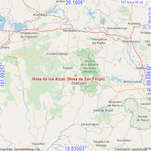
Mesa de los Alzati (Mesa de San Felipe) GPS coordinates[2]
19° 29' 57.012" North, 100° 23' 21.984" West
| Map corner | latitude | longitude |
|---|---|---|
| Upper-left | 20.1606°, | -101.09257° |
| Center: | 19.49917°, | -100.38944° |
| Lower-right: | 18.83503°, | -99.68632° |
| Map W x H: | 147.4×147.4 km | = 91.6×91.6mi |
| max Lat: | 32.7° ⇑54% North |
| Mesa de los Alzati (Mesa de San Felipe): | 19.49917° |
| min Lat: | ⇓46% South 14.53588° |
| min Long | Mesa de los Alz | max Long |
| -117.105° | -100.38944° | -86.73105° |
| W 31.7%⇐ | ⇒68.3% E |
Elevation
Elevation of Mesa de los Alzati (Mesa de San Felipe) is 1998 m = 6555 ft, and this is 744.3 m = 2442 ft above average elevation for this country.
| Max E: |
3497 m = 11473 ft | 26.7% |
| Mesa de los Alzati (Mesa de San Felipe) | 1998 m 6555 ft | |
| Avg. | 1253.7 m = 4113 ft | |
Min E: |
-1 m = -3 ft | 73.3% |
See also: Mexico elevation on elevation.city.
Geographical zone
Mesa de los Alzati (Mesa de San Felipe) is located in North Torrid zone (between Equator and Tropic of Cancer). Distance of this Northern Tropic circle is 437.8 km =272 mi to North.| Distance of | km | miles | from Mesa de los Alzati (Mesa de San Felipe) |
|---|---|---|---|
| North Pole | 7839 | 4870.9 | to North |
| Arctic Circle | 5233.1 | 3251.7 | to North |
| Tropic Cancer | 437.8 | 272 | to North |
| Equator | 2168.1 | 1347.2 | to South |


Nearby cities:
15 places around Mesa de los Alzati (Mesa de San Felipe): (largest is in red/bold)
• Curungueo
6.2 km =3.9 mi,  128°
128°
• El Rincón de San Felipe (Tercera Manzana San Felipe)
1.9 km =1.2 mi,  65°
65°
• La Manzana de Santa Cruz
5.5 km =3.4 mi,  31°
31°
• La Presa (Segunda Manzana Barrio de Santa Cruz)
3.8 km =2.4 mi,  329°
329°
• Loma Larga
5.5 km =3.4 mi,  147°
147°
• Macutzio
3.6 km =2.2 mi,  90°
90°
• Manzana la Cofradía
6.6 km =4.1 mi, 32°
• Ocurio
4 km =2.5 mi,  242°
242°
• Puentecillas (Tercera Manzana de Zirahuato)
1.8 km =1.1 mi,  291°
291°
• Puerto Azul (Quinta Manzana de San Felipe)
2.3 km =1.4 mi,  200°
200°
• Rincón de Corucha
6.5 km =4 mi,  315°
315°
• Rincón de Curungueo
5.1 km =3.2 mi,  110°
110°
• San Felipe los Alzati (Colonia Nueva)
1.9 km =1.2 mi,  122°
122°
• Valle Verde
4.6 km =2.9 mi, 129°
• Zirahuato de los Bernal
3 km =1.9 mi, 323°
Sources, notices
• [Note1] Compared only with cities in Mexico existing in our database
• [Src1] Map data: © OpenStreetMap contributors (CC-BY-SA)
• [Src2] Other city data from geonames.org with taken over terms of usage.
• [Src3] Geographical zone / Annual Mean Temperature by Robert A. Rohde @ Wikipedia
