El Bajío (La Laguna) geodata
El Bajío (La Laguna) (Jalisco) is a populated place; located in Mexico in America/Mexico_City (GMT-6) time zone. With population of 1,001 people, there are 8710 cities with bigger population in this country. Compared to other cities in Mexico, 80.7% of cities are located further ↓South; 80.6% of cities are located further →East and 67.5% of cities have lower elevation than El Bajío (La Laguna). Note1
Current local time in El Bajío (La Laguna):
08:08 AM, WednesdayDifference from your time zone: hours


El Bajío (La Laguna) GPS coordinates[2]
21° 22' 45.984" North, 101° 57' 1.008" West
| Map corner | latitude | longitude |
|---|---|---|
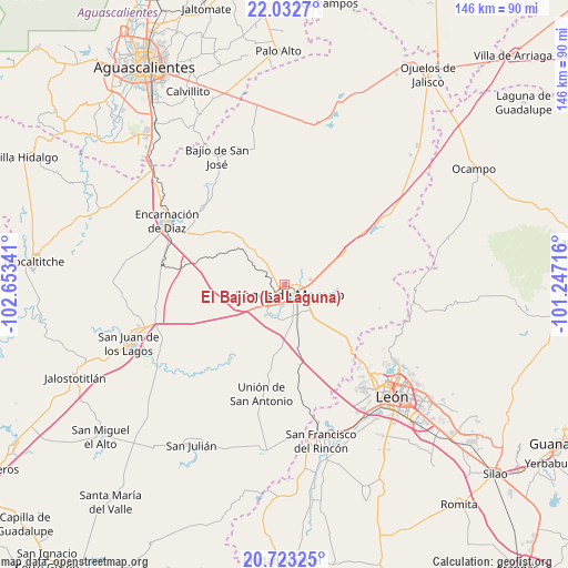
| Upper-left | 22.0327°, | -102.65341° |
| Center: | 21.37944°, | -101.95028° |
| Lower-right: | 20.72325°, | -101.24716° |
| Map W x H: | 145.6×145.6 km | = 90.5×90.5mi |
| max Lat: | 32.7° ⇑19.3% North |
| El Bajío (La Laguna): | 21.37944° |
| min Lat: | ⇓80.7% South 14.53588° |
| min Long | El Bajío (La L | max Long |
| -117.105° | -101.95028° | -86.73105° |
| W 19.4%⇐ | ⇒80.6% E |
Elevation
Elevation of El Bajío (La Laguna) is 1879 m = 6165 ft, and this is 625.3 m = 2052 ft above average elevation for this country.
| Max E: |
3497 m = 11473 ft | 32.5% |
| El Bajío (La Laguna) | 1879 m 6165 ft | |
| Avg. | 1253.7 m = 4113 ft | |
Min E: |
-1 m = -3 ft | 67.5% |
See also: Mexico elevation on elevation.city.
Geographical zone
El Bajío (La Laguna) is located in North Torrid zone (between Equator and Tropic of Cancer). Distance of this Northern Tropic circle is 228.7 km =142.1 mi to North.| Distance of | km | miles | from El Bajío (La Laguna) |
|---|---|---|---|
| North Pole | 7629.9 | 4741 | to North |
| Arctic Circle | 5024 | 3121.8 | to North |
| Tropic Cancer | 228.7 | 142.1 | to North |
| Equator | 2377.2 | 1477.1 | to South |


Nearby cities:
15 places around El Bajío (La Laguna): (largest is in red/bold)
• Buenavista (San Miguel)
1.9 km =1.2 mi,  311°
311°
• Chipinque de Arriba
7.4 km =4.6 mi,  37°
37°
• Cristeros [Fraccionamiento]
6.9 km =4.3 mi,  200°
200°
• Dieciocho de Marzo
19.4 km =12.1 mi,  53°
53°
• El Ojuelo
11.9 km =7.4 mi,  78°
78°
• El Refugio (El Maguey)
16.9 km =10.5 mi,  71°
71°
• Geovillas Laureles del Campanario
6.1 km =3.8 mi,  153°
153°
• Granadillas (La Colonia)
5.1 km =3.2 mi,  89°
89°
• La Orilla del Agua
0.5 km =0.3 mi,  335°
335°
• Lagos de Moreno
2.8 km =1.7 mi, 152°
• Las Cruces
19.7 km =12.2 mi, 149°
• Plan de los Rodríguez
6.6 km =4.1 mi,  168°
168°
• Primero de Mayo (Chupaderos)
16 km =9.9 mi, 52°
• San Antonio de Buenavista
15 km =9.3 mi,  30°
30°
• Torrecillas (El Lindero)
1.5 km =0.9 mi,  266°
266°
Sources, notices
• [Note1] Compared only with cities in Mexico existing in our database
• [Src1] Map data: © OpenStreetMap contributors (CC-BY-SA)
• [Src2] Other city data from geonames.org with taken over terms of usage.
• [Src3] Geographical zone / Annual Mean Temperature by Robert A. Rohde @ Wikipedia
