Buenavista (San Miguel) geodata
Buenavista (San Miguel) (Jalisco) is a populated place; located in Mexico in America/Mexico_City (GMT-6) time zone. With population of 819 people, there are 10664 cities with bigger population in this country. Compared to other cities in Mexico, 80.8% of cities are located further ↓South; 80.7% of cities are located further →East and 67.9% of cities have lower elevation than Buenavista (San Miguel). Note1
Current local time in Buenavista (San Miguel):
07:21 AM, MondayDifference from your time zone: hours


Buenavista (San Miguel) GPS coordinates[2]
21° 23' 26.988" North, 101° 57' 51.012" West
| Map corner | latitude | longitude |
|---|---|---|
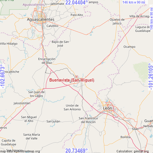
| Upper-left | 22.04404°, | -102.6673° |
| Center: | 21.39083°, | -101.96417° |
| Lower-right: | 20.73469°, | -101.26105° |
| Map W x H: | 145.6×145.6 km | = 90.5×90.5mi |
| max Lat: | 32.7° ⇑19.2% North |
| Buenavista (San Miguel): | 21.39083° |
| min Lat: | ⇓80.8% South 14.53588° |
| min Long | Buenavista (San | max Long |
| -117.105° | -101.96417° | -86.73105° |
| W 19.3%⇐ | ⇒80.7% E |
Elevation
Elevation of Buenavista (San Miguel) is 1887 m = 6191 ft, and this is 633.3 m = 2078 ft above average elevation for this country.
| Max E: |
3497 m = 11473 ft | 32.1% |
| Buenavista (San Miguel) | 1887 m 6191 ft | |
| Avg. | 1253.7 m = 4113 ft | |
Min E: |
-1 m = -3 ft | 67.9% |
See also: Mexico elevation on elevation.city.
Geographical zone
Buenavista (San Miguel) is located in North Torrid zone (between Equator and Tropic of Cancer). Distance of this Northern Tropic circle is 227.5 km =141.4 mi to North.| Distance of | km | miles | from Buenavista (San Miguel) |
|---|---|---|---|
| North Pole | 7628.6 | 4740.2 | to North |
| Arctic Circle | 5022.7 | 3121 | to North |
| Tropic Cancer | 227.5 | 141.4 | to North |
| Equator | 2378.4 | 1477.9 | to South |


Nearby cities:
15 places around Buenavista (San Miguel): (largest is in red/bold)
• Chipinque de Arriba
7.5 km =4.7 mi,  52°
52°
• Corral de Piedra
19 km =11.8 mi,  302°
302°
• Cristeros [Fraccionamiento]
7.8 km =4.8 mi,  186°
186°
• Dieciocho de Marzo
19.9 km =12.4 mi,  59°
59°
• El Bajío (La Laguna)
1.9 km =1.2 mi,  131°
131°
• El Ojuelo
13.2 km =8.2 mi,  84°
84°
• El Refugio (El Maguey)
18 km =11.2 mi, 76°
• Geovillas Laureles del Campanario
7.9 km =4.9 mi,  147°
147°
• Granadillas (La Colonia)
6.6 km =4.1 mi,  100°
100°
• La Orilla del Agua
1.4 km =0.9 mi,  122°
122°
• Lagos de Moreno
4.7 km =2.9 mi,  144°
144°
• Plan de los Rodríguez
8.2 km =5.1 mi,  160°
160°
• Primero de Mayo (Chupaderos)
16.5 km =10.3 mi, 59°
• San Antonio de Buenavista
14.8 km =9.2 mi,  37°
37°
• Torrecillas (El Lindero)
1.4 km =0.9 mi,  183°
183°
Sources, notices
• [Note1] Compared only with cities in Mexico existing in our database
• [Src1] Map data: © OpenStreetMap contributors (CC-BY-SA)
• [Src2] Other city data from geonames.org with taken over terms of usage.
• [Src3] Geographical zone / Annual Mean Temperature by Robert A. Rohde @ Wikipedia
