La Paja geodata
La Paja (State of Mexico) is a populated place; located in Mexico in America/Mexico_City (GMT-6) time zone. With population of 963 people, there are 9035 cities with bigger population in this country. Compared to other cities in Mexico, 55.9% of cities are located further ↑North; 58% of cities are located further →East and 94.6% of cities have lower elevation than La Paja. Note1


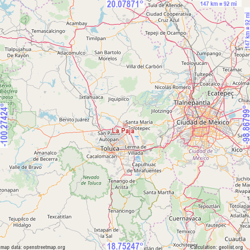
La Paja GPS coordinates[2]
19° 25' 0.984" North, 99° 34' 15.996" West
| Map corner | latitude | longitude |
|---|---|---|
| Upper-left | 20.07871°, | -100.27424° |
| Center: | 19.41694°, | -99.57111° |
| Lower-right: | 18.75247°, | -98.86799° |
| Map W x H: | 147.5×147.5 km | = 91.7×91.7mi |
| max Lat: | 32.7° ⇑55.9% North |
| La Paja: | 19.41694° |
| min Lat: | ⇓44.1% South 14.53588° |
| min Long | La Paja | max Long |
| -117.105° | -99.57111° | -86.73105° |
| W 42%⇐ | ⇒58% E |
Elevation
Elevation of La Paja is 2586 m = 8484 ft, and this is 1332.3 m = 4371 ft above average elevation for this country.
| Max E: |
3497 m = 11473 ft | 5.4% |
| La Paja | 2586 m 8484 ft | |
| Avg. | 1253.7 m = 4113 ft | |
Min E: |
-1 m = -3 ft | 94.6% |
See also: Mexico elevation on elevation.city.
Geographical zone
La Paja is located in North Torrid zone (between Equator and Tropic of Cancer). Distance of this Northern Tropic circle is 447 km =277.8 mi to North.| Distance of | km | miles | from La Paja |
|---|---|---|---|
| North Pole | 7848.1 | 4876.6 | to North |
| Arctic Circle | 5242.2 | 3257.4 | to North |
| Tropic Cancer | 447 | 277.8 | to North |
| Equator | 2159 | 1341.5 | to South |


Nearby cities:
15 places around La Paja: (largest is in red/bold)
• Barrio de San Juan
3.6 km =2.2 mi,  94°
94°
• Barrio de la Barranca
2.5 km =1.6 mi,  32°
32°
• Colonia Adolfo López Mateos
4.5 km =2.8 mi,  95°
95°
• Fraccionamiento Rinconada del Valle
0.7 km =0.4 mi,  206°
206°
• La Joya
2.7 km =1.7 mi,  190°
190°
• La Loma de Puente San Pedro
1.4 km =0.9 mi,  259°
259°
• La Raya
0.7 km =0.4 mi,  18°
18°
• La Y
2.9 km =1.8 mi,  222°
222°
• San Agustín Mimbres
4.1 km =2.5 mi, 22°
• San Blas Otzacatipan
4.3 km =2.7 mi,  173°
173°
• San Isidro las Trojes
3.8 km =2.4 mi,  61°
61°
• San José Buenavista el Grande
1.4 km =0.9 mi,  228°
228°
• San Lorenzo Oyamel
2 km =1.2 mi,  339°
339°
• San Mateo Mozoquilpan
2.6 km =1.6 mi,  42°
42°
• Villa Cuauhtémoc
1.3 km =0.8 mi, 90°
Sources, notices
• [Note1] Compared only with cities in Mexico existing in our database
• [Src1] Map data: © OpenStreetMap contributors (CC-BY-SA)
• [Src2] Other city data from geonames.org with taken over terms of usage.
• [Src3] Geographical zone / Annual Mean Temperature by Robert A. Rohde @ Wikipedia
