San Lorenzo Oyamel geodata
San Lorenzo Oyamel (Morelos) is a populated place; located in Mexico in America/Mexico_City (GMT-6) time zone. With population of 5,753 people, there are 1620 cities with bigger population in this country. Compared to other cities in Mexico, 55.4% of cities are located further ↑North; 58.1% of cities are located further →East and 95.4% of cities have lower elevation than San Lorenzo Oyamel. Note1


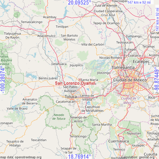
San Lorenzo Oyamel GPS coordinates[2]
19° 26' 0.78" North, 99° 34' 39.396" West
| Map corner | latitude | longitude |
|---|---|---|
| Upper-left | 20.09525°, | -100.28074° |
| Center: | 19.43355°, | -99.57761° |
| Lower-right: | 18.76914°, | -98.87449° |
| Map W x H: | 147.4×147.5 km | = 91.6×91.7mi |
| max Lat: | 32.7° ⇑55.4% North |
| San Lorenzo Oyamel: | 19.43355° |
| min Lat: | ⇓44.6% South 14.53588° |
| min Long | San Lorenzo Oya | max Long |
| -117.105° | -99.57761° | -86.73105° |
| W 41.9%⇐ | ⇒58.1% E |
Elevation
Elevation of San Lorenzo Oyamel is 2605 m = 8547 ft, and this is 1351.3 m = 4433 ft above average elevation for this country.
| Max E: |
3497 m = 11473 ft | 4.6% |
| San Lorenzo Oyamel | 2605 m 8547 ft | |
| Avg. | 1253.7 m = 4113 ft | |
Min E: |
-1 m = -3 ft | 95.4% |
See also: Mexico elevation on elevation.city.
Geographical zone
San Lorenzo Oyamel is located in North Torrid zone (between Equator and Tropic of Cancer). Distance of this Northern Tropic circle is 445.1 km =276.6 mi to North.| Distance of | km | miles | from San Lorenzo Oyamel |
|---|---|---|---|
| North Pole | 7846.3 | 4875.5 | to North |
| Arctic Circle | 5240.4 | 3256.2 | to North |
| Tropic Cancer | 445.1 | 276.6 | to North |
| Equator | 2160.8 | 1342.7 | to South |


Nearby cities:
15 places around San Lorenzo Oyamel: (largest is in red/bold)
• Barrio de la Barranca
2 km =1.2 mi,  82°
82°
• Ejido de Dolores
3.7 km =2.3 mi,  265°
265°
• Fraccionamiento Rinconada del Valle
2.5 km =1.6 mi,  171°
171°
• La Loma de Puente San Pedro
2.2 km =1.4 mi,  197°
197°
• La Magdalena Tenexpan
3.5 km =2.2 mi,  340°
340°
• La Paja
2 km =1.2 mi,  159°
159°
• La Raya
1.5 km =0.9 mi,  144°
144°
• La Y
4.1 km =2.5 mi, 197°
• Loma de San Nicolás
3 km =1.9 mi,  284°
284°
• Molino Abajo
3.1 km =1.9 mi,  304°
304°
• San Agustín Mimbres
2.9 km =1.8 mi,  49°
49°
• San Isidro las Trojes
4 km =2.5 mi,  90°
90°
• San José Buenavista el Grande
2.8 km =1.7 mi,  188°
188°
• San Mateo Mozoquilpan
2.4 km =1.5 mi, 88°
• Villa Cuauhtémoc
2.7 km =1.7 mi,  133°
133°
Sources, notices
• [Note1] Compared only with cities in Mexico existing in our database
• [Src1] Map data: © OpenStreetMap contributors (CC-BY-SA)
• [Src2] Other city data from geonames.org with taken over terms of usage.
• [Src3] Geographical zone / Annual Mean Temperature by Robert A. Rohde @ Wikipedia
