Tasajillo geodata
Tasajillo (Guanajuato) is a populated place; located in Mexico in America/Mexico_City (GMT-6) time zone. With population of 911 people, there are 9575 cities with bigger population in this country. Compared to other cities in Mexico, 79.3% of cities are located further ↓South; 66.5% of cities are located further →East and 61.5% of cities have lower elevation than Tasajillo. Note1


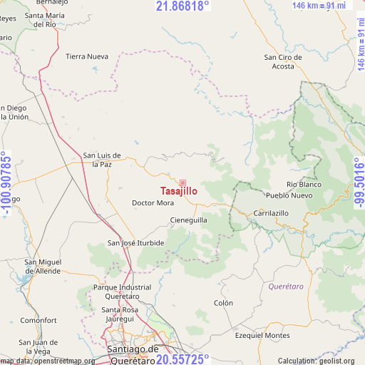
Tasajillo GPS coordinates[2]
21° 12' 51.012" North, 100° 12' 16.992" West
| Map corner | latitude | longitude |
|---|---|---|
| Upper-left | 21.86818°, | -100.90785° |
| Center: | 21.21417°, | -100.20472° |
| Lower-right: | 20.55725°, | -99.5016° |
| Map W x H: | 145.8×145.8 km | = 90.6×90.6mi |
| max Lat: | 32.7° ⇑20.7% North |
| Tasajillo: | 21.21417° |
| min Lat: | ⇓79.3% South 14.53588° |
| min Long | Tasajillo | max Long |
| -117.105° | -100.20472° | -86.73105° |
| W 33.5%⇐ | ⇒66.5% E |
Elevation
Elevation of Tasajillo is 1750 m = 5741 ft, and this is 496.3 m = 1628 ft above average elevation for this country.
| Max E: |
3497 m = 11473 ft | 38.5% |
| Tasajillo | 1750 m 5741 ft | |
| Avg. | 1253.7 m = 4113 ft | |
Min E: |
-1 m = -3 ft | 61.5% |
See also: Mexico elevation on elevation.city.
Geographical zone
Tasajillo is located in North Torrid zone (between Equator and Tropic of Cancer). Distance of this Northern Tropic circle is 247.1 km =153.5 mi to North.| Distance of | km | miles | from Tasajillo |
|---|---|---|---|
| North Pole | 7648.3 | 4752.4 | to North |
| Arctic Circle | 5042.4 | 3133.2 | to North |
| Tropic Cancer | 247.1 | 153.5 | to North |
| Equator | 2358.8 | 1465.7 | to South |


Nearby cities:
15 places around Tasajillo: (largest is in red/bold)
• Carmen
12.3 km =7.6 mi,  284°
284°
• Cerro Colorado
12.7 km =7.9 mi,  192°
192°
• Cieneguilla
8.1 km =5 mi,  297°
297°
• Cieneguilla
15 km =9.3 mi,  170°
170°
• Cuesta de Peñones
14.8 km =9.2 mi, 192°
• Doctor Mora
14.3 km =8.9 mi,  236°
236°
• Fracción de Guadalupe
10.8 km =6.7 mi,  149°
149°
• Los Linderos
3.2 km =2 mi,  288°
288°
• Los Remedios
3.3 km =2.1 mi, 170°
• Milpillas de Santiago
3.1 km =1.9 mi,  118°
118°
• Misión de Arnedo
5.3 km =3.3 mi, 290°
• Palmillas
3.5 km =2.2 mi,  314°
314°
• Tierra Blanca
13.5 km =8.4 mi,  159°
159°
• Torrecitas
14.3 km =8.9 mi,  177°
177°
• Victoria
1.1 km =0.7 mi,  256°
256°
Sources, notices
• [Note1] Compared only with cities in Mexico existing in our database
• [Src1] Map data: © OpenStreetMap contributors (CC-BY-SA)
• [Src2] Other city data from geonames.org with taken over terms of usage.
• [Src3] Geographical zone / Annual Mean Temperature by Robert A. Rohde @ Wikipedia
