Cieneguilla geodata
Cieneguilla (Guanajuato) is a populated place; located in Mexico in America/Mexico_City (GMT-6) time zone. With population of 1,190 people, there are 7298 cities with bigger population in this country. Compared to other cities in Mexico, 79.6% of cities are located further ↓South; 67.1% of cities are located further →East and 65.2% of cities have lower elevation than Cieneguilla. Note1


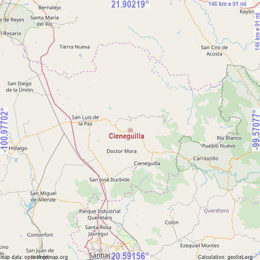
Cieneguilla GPS coordinates[2]
21° 14' 53.988" North, 100° 16' 26.004" West
| Map corner | latitude | longitude |
|---|---|---|
| Upper-left | 21.90219°, | -100.97702° |
| Center: | 21.24833°, | -100.27389° |
| Lower-right: | 20.59156°, | -99.57077° |
| Map W x H: | 145.7×145.7 km | = 90.5×90.5mi |
| max Lat: | 32.7° ⇑20.4% North |
| Cieneguilla: | 21.24833° |
| min Lat: | ⇓79.6% South 14.53588° |
| min Long | Cieneguilla | max Long |
| -117.105° | -100.27389° | -86.73105° |
| W 32.9%⇐ | ⇒67.1% E |
Elevation
Elevation of Cieneguilla is 1834 m = 6017 ft, and this is 580.3 m = 1904 ft above average elevation for this country.
| Max E: |
3497 m = 11473 ft | 34.8% |
| Cieneguilla | 1834 m 6017 ft | |
| Avg. | 1253.7 m = 4113 ft | |
Min E: |
-1 m = -3 ft | 65.2% |
See also: Mexico elevation on elevation.city.
Geographical zone
Cieneguilla is located in North Torrid zone (between Equator and Tropic of Cancer). Distance of this Northern Tropic circle is 243.3 km =151.2 mi to North.| Distance of | km | miles | from Cieneguilla |
|---|---|---|---|
| North Pole | 7644.5 | 4750.1 | to North |
| Arctic Circle | 5038.6 | 3130.8 | to North |
| Tropic Cancer | 243.3 | 151.2 | to North |
| Equator | 2362.6 | 1468.1 | to South |


Nearby cities:
15 places around Cieneguilla: (largest is in red/bold)
• Carmen
4.8 km =3 mi,  260°
260°
• Cerro Colorado
16.7 km =10.4 mi,  164°
164°
• Derramadero de Charcas
15.9 km =9.9 mi,  192°
192°
• Doctor Mora
12.7 km =7.9 mi,  201°
201°
• Ex-Hacienda de Ortega (Ejido Ortega)
13.8 km =8.6 mi,  282°
282°
• Loma de Buenavista
10.7 km =6.6 mi,  224°
224°
• Los Linderos
5 km =3.1 mi,  124°
124°
• Los Remedios
10.5 km =6.5 mi,  132°
132°
• Milpillas de Santiago
11.2 km =7 mi, 118°
• Misión de Arnedo
2.9 km =1.8 mi, 131°
• Palmillas
4.9 km =3 mi,  106°
106°
• San Rafael
15.3 km =9.5 mi,  213°
213°
• Tasajillo
8.1 km =5 mi, 117°
• Vagui
11.9 km =7.4 mi, 216°
• Victoria
7.3 km =4.5 mi, 123°
Sources, notices
• [Note1] Compared only with cities in Mexico existing in our database
• [Src1] Map data: © OpenStreetMap contributors (CC-BY-SA)
• [Src2] Other city data from geonames.org with taken over terms of usage.
• [Src3] Geographical zone / Annual Mean Temperature by Robert A. Rohde @ Wikipedia
