Zacatlamanic geodata
Zacatlamanic (Puebla) is a populated place; located in Mexico in America/Mexico_City (GMT-6) time zone. With population of 867 people, there are 10083 cities with bigger population in this country. Compared to other cities in Mexico, 73.3% of cities are located further ↑North; 74.3% of cities are located further ←West and 92.5% of cities have lower elevation than Zacatlamanic. Note1


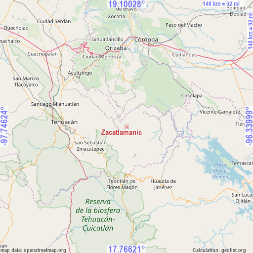
Zacatlamanic GPS coordinates[2]
18° 26' 4.344" North, 97° 2' 35.196" West
| Map corner | latitude | longitude |
|---|---|---|
| Upper-left | 19.10028°, | -97.74624° |
| Center: | 18.43454°, | -97.04311° |
| Lower-right: | 17.76621°, | -96.33999° |
| Map W x H: | 148.3×148.3 km | = 92.1×92.1mi |
| max Lat: | 32.7° ⇑73.3% North |
| Zacatlamanic: | 18.43454° |
| min Lat: | ⇓26.7% South 14.53588° |
| min Long | Zacatlamanic | max Long |
| -117.105° | -97.04311° | -86.73105° |
| W 74.3%⇐ | ⇒25.7% E |
Elevation
Elevation of Zacatlamanic is 2505 m = 8219 ft, and this is 1251.3 m = 4105 ft above average elevation for this country.
| Max E: |
3497 m = 11473 ft | 7.5% |
| Zacatlamanic | 2505 m 8219 ft | |
| Avg. | 1253.7 m = 4113 ft | |
Min E: |
-1 m = -3 ft | 92.5% |
See also: Mexico elevation on elevation.city.
Geographical zone
Zacatlamanic is located in North Torrid zone (between Equator and Tropic of Cancer). Distance of this Northern Tropic circle is 556.2 km =345.6 mi to North.| Distance of | km | miles | from Zacatlamanic |
|---|---|---|---|
| North Pole | 7957.3 | 4944.4 | to North |
| Arctic Circle | 5351.4 | 3325.2 | to North |
| Tropic Cancer | 556.2 | 345.6 | to North |
| Equator | 2049.7 | 1273.6 | to South |


Nearby cities:
15 places around Zacatlamanic: (largest is in red/bold)
• Chichicapa
3.8 km =2.4 mi,  186°
186°
• Coxolico
2.3 km =1.4 mi,  37°
37°
• Cuabcapula
3.3 km =2.1 mi,  133°
133°
• Cuahuichotla
4.1 km =2.5 mi,  325°
325°
• Cuaxuxpa
3.2 km =2 mi,  14°
14°
• Loma Bonita
3 km =1.9 mi,  158°
158°
• Mazatianquixco
3.8 km =2.4 mi,  273°
273°
• Mexcaltochintla
1.5 km =0.9 mi, 190°
• Moyotepec
4.7 km =2.9 mi,  290°
290°
• Rancho Nuevo
3.3 km =2.1 mi, 326°
• San Sebastián Alcomunga
1.7 km =1.1 mi,  80°
80°
• Tecpantzacoalco
4.7 km =2.9 mi,  4°
4°
• Tepetlampa
2 km =1.2 mi,  229°
229°
• Vista Hermosa Zayulapa
5.8 km =3.6 mi, 266°
• Ízhuapa
6.2 km =3.9 mi,  154°
154°
Sources, notices
• [Note1] Compared only with cities in Mexico existing in our database
• [Src1] Map data: © OpenStreetMap contributors (CC-BY-SA)
• [Src2] Other city data from geonames.org with taken over terms of usage.
• [Src3] Geographical zone / Annual Mean Temperature by Robert A. Rohde @ Wikipedia
