Cuaxuxpa geodata
Cuaxuxpa (Puebla) is a populated place; located in Mexico in America/Mexico_City (GMT-6) time zone. With population of 1,772 people, there are 4897 cities with bigger population in this country. Compared to other cities in Mexico, 73% of cities are located further ↑North; 74.4% of cities are located further ←West and 87% of cities have lower elevation than Cuaxuxpa. Note1


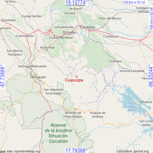
Cuaxuxpa GPS coordinates[2]
18° 27' 43.596" North, 97° 2' 8.016" West
| Map corner | latitude | longitude |
|---|---|---|
| Upper-left | 19.12774°, | -97.73869° |
| Center: | 18.46211°, | -97.03556° |
| Lower-right: | 17.79389°, | -96.33244° |
| Map W x H: | 148.3×148.3 km | = 92.1×92.1mi |
| max Lat: | 32.7° ⇑73% North |
| Cuaxuxpa: | 18.46211° |
| min Lat: | ⇓27% South 14.53588° |
| min Long | Cuaxuxpa | max Long |
| -117.105° | -97.03556° | -86.73105° |
| W 74.4%⇐ | ⇒25.6% E |
Elevation
Elevation of Cuaxuxpa is 2309 m = 7575 ft, and this is 1055.3 m = 3462 ft above average elevation for this country.
| Max E: |
3497 m = 11473 ft | 13% |
| Cuaxuxpa | 2309 m 7575 ft | |
| Avg. | 1253.7 m = 4113 ft | |
Min E: |
-1 m = -3 ft | 87% |
See also: Mexico elevation on elevation.city.
Geographical zone
Cuaxuxpa is located in North Torrid zone (between Equator and Tropic of Cancer). Distance of this Northern Tropic circle is 553.1 km =343.7 mi to North.| Distance of | km | miles | from Cuaxuxpa |
|---|---|---|---|
| North Pole | 7954.3 | 4942.6 | to North |
| Arctic Circle | 5348.4 | 3323.3 | to North |
| Tropic Cancer | 553.1 | 343.7 | to North |
| Equator | 2052.8 | 1275.6 | to South |


Nearby cities:
15 places around Cuaxuxpa: (largest is in red/bold)
• Achichinalco
5.4 km =3.4 mi,  60°
60°
• Apipitzactitla
4.6 km =2.9 mi,  334°
334°
• Coxolico
1.4 km =0.9 mi,  154°
154°
• Cuabcapula
5.6 km =3.5 mi,  163°
163°
• Cuahuichotla
3.2 km =2 mi,  275°
275°
• Esperanza
3.4 km =2.1 mi,  354°
354°
• Mazatianquixco
5.3 km =3.3 mi,  238°
238°
• Mexcaltochintla
4.6 km =2.9 mi,  193°
193°
• Moyotepec
5.4 km =3.4 mi,  254°
254°
• Rancho Nuevo
2.6 km =1.6 mi,  263°
263°
• San Sebastián Alcomunga
2.9 km =1.8 mi, 161°
• Tecpantzacoalco
1.7 km =1.1 mi, 346°
• Tepecuitlapa
4.8 km =3 mi,  309°
309°
• Tepetlampa
4.9 km =3 mi,  208°
208°
• Zacatlamanic
3.2 km =2 mi, 194°
Sources, notices
• [Note1] Compared only with cities in Mexico existing in our database
• [Src1] Map data: © OpenStreetMap contributors (CC-BY-SA)
• [Src2] Other city data from geonames.org with taken over terms of usage.
• [Src3] Geographical zone / Annual Mean Temperature by Robert A. Rohde @ Wikipedia
