Corral de Piedra geodata
Corral de Piedra (Jalisco) is a populated place; located in Mexico in America/Mexico_City (GMT-6) time zone. With population of 572 people, there are 14957 cities with bigger population in this country. Compared to other cities in Mexico, 81.3% of cities are located further ↓South; 81.7% of cities are located further →East and 70.5% of cities have lower elevation than Corral de Piedra. Note1


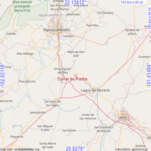
Corral de Piedra GPS coordinates[2]
21° 28' 59.988" North, 102° 7' 5.016" West
| Map corner | latitude | longitude |
|---|---|---|
| Upper-left | 22.13612°, | -102.82119° |
| Center: | 21.48333°, | -102.11806° |
| Lower-right: | 20.8276°, | -101.41494° |
| Map W x H: | 145.5×145.5 km | = 90.4×90.4mi |
| max Lat: | 32.7° ⇑18.7% North |
| Corral de Piedra: | 21.48333° |
| min Lat: | ⇓81.3% South 14.53588° |
| min Long | Corral de Piedr | max Long |
| -117.105° | -102.11806° | -86.73105° |
| W 18.3%⇐ | ⇒81.7% E |
Elevation
Elevation of Corral de Piedra is 1935 m = 6348 ft, and this is 681.3 m = 2235 ft above average elevation for this country.
| Max E: |
3497 m = 11473 ft | 29.5% |
| Corral de Piedra | 1935 m 6348 ft | |
| Avg. | 1253.7 m = 4113 ft | |
Min E: |
-1 m = -3 ft | 70.5% |
See also: Mexico elevation on elevation.city.
Geographical zone
Corral de Piedra is located in North Torrid zone (between Equator and Tropic of Cancer). Distance of this Northern Tropic circle is 217.2 km =135 mi to North.| Distance of | km | miles | from Corral de Piedra |
|---|---|---|---|
| North Pole | 7618.3 | 4733.8 | to North |
| Arctic Circle | 5012.5 | 3114.6 | to North |
| Tropic Cancer | 217.2 | 135 | to North |
| Equator | 2388.7 | 1484.3 | to South |


Nearby cities:
15 places around Corral de Piedra: (largest is in red/bold)
• Bajío de San José
21.3 km =13.2 mi,  0°
0°
• Buenavista (San Miguel)
19 km =11.8 mi,  122°
122°
• Chipinque de Arriba
22.6 km =14 mi,  104°
104°
• Cristeros [Fraccionamiento]
23.4 km =14.5 mi,  140°
140°
• El Bajío (La Laguna)
20.9 km =13 mi, 123°
• El Puesto
22.3 km =13.9 mi,  45°
45°
• El Salvador
19.6 km =12.2 mi,  312°
312°
• Encarnación de Díaz
13.5 km =8.4 mi,  291°
291°
• La Orilla del Agua
20.4 km =12.7 mi, 122°
• Lagos de Moreno
23.4 km =14.5 mi,  127°
127°
• Mesón de los Sauces
10.3 km =6.4 mi,  348°
348°
• Santa Bárbara
6.7 km =4.2 mi,  223°
223°
• Santa María Transpontina
16.3 km =10.1 mi,  242°
242°
• Santa María de Enmedio
12.9 km =8 mi, 236°
• Torrecillas (El Lindero)
19.7 km =12.2 mi, 126°
Sources, notices
• [Note1] Compared only with cities in Mexico existing in our database
• [Src1] Map data: © OpenStreetMap contributors (CC-BY-SA)
• [Src2] Other city data from geonames.org with taken over terms of usage.
• [Src3] Geographical zone / Annual Mean Temperature by Robert A. Rohde @ Wikipedia
