Ayotzinapan geodata
Ayotzinapan (Puebla) is a populated place; located in Mexico in America/Mexico_City (GMT-6) time zone. With population of 817 people, there are 10690 cities with bigger population in this country. Compared to other cities in Mexico, 58.2% of cities are located further ↓South; 69.1% of cities are located further ←West and 67.1% of cities have higher elevation than Ayotzinapan. Note1


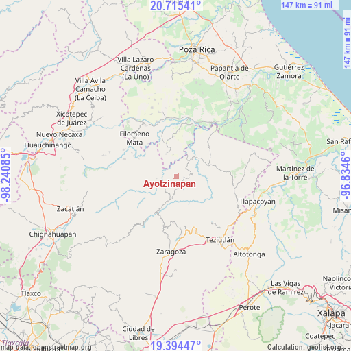
Ayotzinapan GPS coordinates[2]
20° 3' 22.788" North, 97° 32' 15.792" West
| Map corner | latitude | longitude |
|---|---|---|
| Upper-left | 20.71541°, | -98.24085° |
| Center: | 20.05633°, | -97.53772° |
| Lower-right: | 19.39447°, | -96.8346° |
| Map W x H: | 146.9×146.9 km | = 91.3×91.3mi |
| max Lat: | 32.7° ⇑41.8% North |
| Ayotzinapan: | 20.05633° |
| min Lat: | ⇓58.2% South 14.53588° |
| min Long | Ayotzinapan | max Long |
| -117.105° | -97.53772° | -86.73105° |
| W 69.1%⇐ | ⇒30.9% E |
Elevation
Elevation of Ayotzinapan is 578 m = 1896 ft, and this is 675.7 m = 2217 ft below average elevation for this country.
| Max E: |
3497 m = 11473 ft | 67.1% |
| Avg. | 1253.7 m = 4113 ft | |
| Ayotzinapan | 578 m = 1896 ft | |
Min E: |
-1 m = -3 ft | 32.9% |
See also: Mexico elevation on elevation.city.
Geographical zone
Ayotzinapan is located in North Torrid zone (between Equator and Tropic of Cancer). Distance of this Northern Tropic circle is 375.9 km =233.6 mi to North.| Distance of | km | miles | from Ayotzinapan |
|---|---|---|---|
| North Pole | 7777 | 4832.4 | to North |
| Arctic Circle | 5171.1 | 3213.2 | to North |
| Tropic Cancer | 375.9 | 233.6 | to North |
| Equator | 2230.1 | 1385.7 | to South |


Nearby cities:
15 places around Ayotzinapan: (largest is in red/bold)
• Ciudad de Cuetzalan
4.5 km =2.8 mi,  157°
157°
• Cuetzalan
4.6 km =2.9 mi, 160°
• Ecatlán (Santiago Ecatlán)
2 km =1.2 mi,  259°
259°
• Ixtahuata
4.9 km =3 mi,  140°
140°
• Jonotla
4.9 km =3 mi,  233°
233°
• Pahpatapán
5.6 km =3.5 mi,  178°
178°
• Tepetitán Reyeshogpan de Hidalgo
5.5 km =3.4 mi,  56°
56°
• Tepetzintán
2.2 km =1.4 mi,  104°
104°
• Tuzamapan
4.1 km =2.5 mi,  284°
284°
• Tuzamapan Xiloxochico
5.1 km =3.2 mi,  88°
88°
• Tzinacapan
3 km =1.9 mi,  185°
185°
• Xalcuahuta
4.4 km =2.7 mi,  37°
37°
• Xaltipan
3.6 km =2.2 mi,  10°
10°
• Xiloxochico de Rafael Ávila Camacho
5 km =3.1 mi, 103°
• Yohualichan
3.6 km =2.2 mi,  80°
80°
Sources, notices
• [Note1] Compared only with cities in Mexico existing in our database
• [Src1] Map data: © OpenStreetMap contributors (CC-BY-SA)
• [Src2] Other city data from geonames.org with taken over terms of usage.
• [Src3] Geographical zone / Annual Mean Temperature by Robert A. Rohde @ Wikipedia
