La Ribera geodata
La Ribera (Veracruz) is a populated place; located in Mexico in America/Mexico_City (GMT-6) time zone. With population of 817 people, there are 10690 cities with bigger population in this country. Compared to other cities in Mexico, 84.7% of cities are located further ↓South; 66.3% of cities are located further ←West and 95.1% of cities have higher elevation than La Ribera. Note1


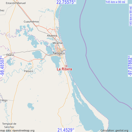
La Ribera GPS coordinates[2]
22° 6' 20.988" North, 97° 46' 54.984" West
| Map corner | latitude | longitude |
|---|---|---|
| Upper-left | 22.75575°, | -98.48507° |
| Center: | 22.10583°, | -97.78194° |
| Lower-right: | 21.4529°, | -97.07882° |
| Map W x H: | 144.9×144.9 km | = 90×90mi |
| max Lat: | 32.7° ⇑15.3% North |
| La Ribera: | 22.10583° |
| min Lat: | ⇓84.7% South 14.53588° |
| min Long | La Ribera | max Long |
| -117.105° | -97.78194° | -86.73105° |
| W 66.3%⇐ | ⇒33.7% E |
Elevation
Elevation of La Ribera is 13 m = 43 ft, and this is 1240.7 m = 4071 ft below average elevation for this country.
| Max E: |
3497 m = 11473 ft | 95.1% |
| Avg. | 1253.7 m = 4113 ft | |
| La Ribera | 13 m = 43 ft | |
Min E: |
-1 m = -3 ft | 4.9% |
See also: Mexico elevation on elevation.city.
Geographical zone
La Ribera is located in North Torrid zone (between Equator and Tropic of Cancer). Distance of this Northern Tropic circle is 148 km =92 mi to North.| Distance of | km | miles | from La Ribera |
|---|---|---|---|
| North Pole | 7549.1 | 4690.8 | to North |
| Arctic Circle | 4943.2 | 3071.6 | to North |
| Tropic Cancer | 148 | 92 | to North |
| Equator | 2457.9 | 1527.3 | to South |


Nearby cities:
15 places around La Ribera: (largest is in red/bold)
• Anahuac
13.1 km =8.1 mi,  325°
325°
• Benito Juárez
12.2 km =7.6 mi, 330°
• Calentadores
32.8 km =20.4 mi,  283°
283°
• Ciudad Cuauhtémoc
10.3 km =6.4 mi, 328°
• Ciudad Madero
19.3 km =12 mi,  343°
343°
• El Crucero (Estación Pedernales)
18.9 km =11.7 mi,  295°
295°
• Emiliano Zapata
25.1 km =15.6 mi,  288°
288°
• Miramar
30.9 km =19.2 mi, 336°
• Miravegas
28 km =17.4 mi,  274°
274°
• Moralillo
18.9 km =11.7 mi,  314°
314°
• Perseverancia
25.5 km =15.8 mi, 299°
• Primero de Mayo
13.8 km =8.6 mi, 343°
• Tampico
22.2 km =13.8 mi, 333°
• Tampico Alto
2.2 km =1.4 mi, 289°
• Vega de Otates
32.9 km =20.4 mi, 266°
Sources, notices
• [Note1] Compared only with cities in Mexico existing in our database
• [Src1] Map data: © OpenStreetMap contributors (CC-BY-SA)
• [Src2] Other city data from geonames.org with taken over terms of usage.
• [Src3] Geographical zone / Annual Mean Temperature by Robert A. Rohde @ Wikipedia
