San Bartolo geodata
San Bartolo (Hidalgo) is a populated place; located in Mexico in America/Mexico_City (GMT-6) time zone. With population of 813 people, there are 10742 cities with bigger population in this country. Compared to other cities in Mexico, 62.5% of cities are located further ↓South; 57.7% of cities are located further ←West and 71.7% of cities have lower elevation than San Bartolo. Note1


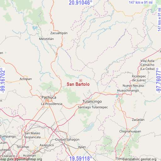
San Bartolo GPS coordinates[2]
20° 15' 7.992" North, 98° 27' 50.004" West
| Map corner | latitude | longitude |
|---|---|---|
| Upper-left | 20.91046°, | -99.16702° |
| Center: | 20.25222°, | -98.46389° |
| Lower-right: | 19.59118°, | -97.76077° |
| Map W x H: | 146.7×146.7 km | = 91.2×91.2mi |
| max Lat: | 32.7° ⇑37.5% North |
| San Bartolo: | 20.25222° |
| min Lat: | ⇓62.5% South 14.53588° |
| min Long | San Bartolo | max Long |
| -117.105° | -98.46389° | -86.73105° |
| W 57.7%⇐ | ⇒42.3% E |
Elevation
Elevation of San Bartolo is 1962 m = 6437 ft, and this is 708.3 m = 2324 ft above average elevation for this country.
| Max E: |
3497 m = 11473 ft | 28.3% |
| San Bartolo | 1962 m 6437 ft | |
| Avg. | 1253.7 m = 4113 ft | |
Min E: |
-1 m = -3 ft | 71.7% |
See also: Mexico elevation on elevation.city.
Geographical zone
San Bartolo is located in North Torrid zone (between Equator and Tropic of Cancer). Distance of this Northern Tropic circle is 354.1 km =220 mi to North.| Distance of | km | miles | from San Bartolo |
|---|---|---|---|
| North Pole | 7755.2 | 4818.9 | to North |
| Arctic Circle | 5149.3 | 3199.6 | to North |
| Tropic Cancer | 354.1 | 220 | to North |
| Equator | 2251.8 | 1399.2 | to South |


Nearby cities:
15 places around San Bartolo: (largest is in red/bold)
• Acatlán
12.1 km =7.5 mi,  167°
167°
• Alcholoya (El Salto de Alcholoya)
3.2 km =2 mi,  158°
158°
• Almoloya
11.3 km =7 mi, 171°
• Colonia 28 de Mayo (Santa Rosa)
12.3 km =7.6 mi,  141°
141°
• Ejido de Agua Blanca (Cerro Alto)
12.5 km =7.8 mi,  49°
49°
• El Acocul
10.2 km =6.3 mi,  108°
108°
• Encinillos
6.9 km =4.3 mi,  151°
151°
• Estación de Apulco
12.7 km =7.9 mi,  72°
72°
• Los Arcos
8.6 km =5.3 mi, 168°
• Mixquiapan
12.4 km =7.7 mi,  189°
189°
• Río Seco Puente de Doria
6 km =3.7 mi,  219°
219°
• San Miguel Regla
10.7 km =6.6 mi,  250°
250°
• Santo Domingo Agua Zarca
11.7 km =7.3 mi,  198°
198°
• Tlaxocoyucan
3.8 km =2.4 mi,  226°
226°
• Vicente Guerrero
9 km =5.6 mi,  126°
126°
Sources, notices
• [Note1] Compared only with cities in Mexico existing in our database
• [Src1] Map data: © OpenStreetMap contributors (CC-BY-SA)
• [Src2] Other city data from geonames.org with taken over terms of usage.
• [Src3] Geographical zone / Annual Mean Temperature by Robert A. Rohde @ Wikipedia
