Jesús Carranza geodata
Jesús Carranza (Tabasco) is a populated place; located in Mexico in America/Mexico_City (GMT-6) time zone. With population of 791 people, there are 11037 cities with bigger population in this country. Compared to other cities in Mexico, 75.7% of cities are located further ↑North; 87.7% of cities are located further ←West and 96.3% of cities have higher elevation than Jesús Carranza. Note1


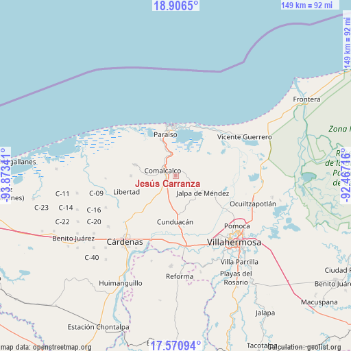
Jesús Carranza GPS coordinates[2]
18° 14' 24" North, 93° 10' 13.008" West
| Map corner | latitude | longitude |
|---|---|---|
| Upper-left | 18.9065°, | -93.87341° |
| Center: | 18.24°, | -93.17028° |
| Lower-right: | 17.57094°, | -92.46716° |
| Map W x H: | 148.5×148.5 km | = 92.3×92.3mi |
| max Lat: | 32.7° ⇑75.7% North |
| Jesús Carranza: | 18.24° |
| min Lat: | ⇓24.3% South 14.53588° |
| min Long | Jesús Carranza | max Long |
| -117.105° | -93.17028° | -86.73105° |
| W 87.7%⇐ | ⇒12.3% E |
Elevation
Elevation of Jesús Carranza is 11 m = 36 ft, and this is 1242.7 m = 4077 ft below average elevation for this country.
| Max E: |
3497 m = 11473 ft | 96.3% |
| Avg. | 1253.7 m = 4113 ft | |
| Jesús Carranza | 11 m = 36 ft | |
Min E: |
-1 m = -3 ft | 3.7% |
See also: Mexico elevation on elevation.city.
Geographical zone
Jesús Carranza is located in North Torrid zone (between Equator and Tropic of Cancer). Distance of this Northern Tropic circle is 577.8 km =359 mi to North.| Distance of | km | miles | from Jesús Carranza |
|---|---|---|---|
| North Pole | 7979 | 4957.9 | to North |
| Arctic Circle | 5373.1 | 3338.7 | to North |
| Tropic Cancer | 577.8 | 359 | to North |
| Equator | 2028.1 | 1260.2 | to South |


Nearby cities:
15 places around Jesús Carranza: (largest is in red/bold)
• Ayapa
6.4 km =4 mi,  105°
105°
• Chichicapa
2.8 km =1.7 mi,  333°
333°
• Comalcalco
6.2 km =3.9 mi,  294°
294°
• Cupilco
4.5 km =2.8 mi,  90°
90°
• El Carmen
3.4 km =2.1 mi,  144°
144°
• Francisco Trujillo Gurría
3.6 km =2.2 mi,  216°
216°
• Gobernadores
1.8 km =1.1 mi,  295°
295°
• Huapacal 2da. Sección (Punta Brava)
4.8 km =3 mi,  182°
182°
• Nicolás Bravo 5ta. Sección (Punta Brava)
6.1 km =3.8 mi,  45°
45°
• Novillero 4ta. Sección
5.9 km =3.7 mi,  84°
84°
• Oriente 1ra. Sección (Santo Domingo)
4.4 km =2.7 mi,  307°
307°
• Oriente 5ta. Sección (La Candelaria)
5.4 km =3.4 mi,  244°
244°
• Potrerillo
4.1 km =2.5 mi,  66°
66°
• Santa Lucía Chichicapa
2.9 km =1.8 mi, 287°
• Uspí
5 km =3.1 mi, 77°
Sources, notices
• [Note1] Compared only with cities in Mexico existing in our database
• [Src1] Map data: © OpenStreetMap contributors (CC-BY-SA)
• [Src2] Other city data from geonames.org with taken over terms of usage.
• [Src3] Geographical zone / Annual Mean Temperature by Robert A. Rohde @ Wikipedia
