Chichicapa geodata
Chichicapa (Tabasco) is a populated place; located in Mexico in America/Mexico_City (GMT-6) time zone. With population of 7,091 people, there are 1310 cities with bigger population in this country. Compared to other cities in Mexico, 75.4% of cities are located further ↑North; 87.7% of cities are located further ←West and 96.3% of cities have higher elevation than Chichicapa. Note1


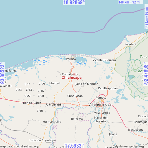
Chichicapa GPS coordinates[2]
18° 15' 44.208" North, 93° 10' 55.56" West
| Map corner | latitude | longitude |
|---|---|---|
| Upper-left | 18.92869°, | -93.88523° |
| Center: | 18.26228°, | -93.1821° |
| Lower-right: | 17.5933°, | -92.47898° |
| Map W x H: | 148.5×148.5 km | = 92.3×92.3mi |
| max Lat: | 32.7° ⇑75.4% North |
| Chichicapa: | 18.26228° |
| min Lat: | ⇓24.6% South 14.53588° |
| min Long | Chichicapa | max Long |
| -117.105° | -93.1821° | -86.73105° |
| W 87.7%⇐ | ⇒12.3% E |
Elevation
Elevation of Chichicapa is 11 m = 36 ft, and this is 1242.7 m = 4077 ft below average elevation for this country.
| Max E: |
3497 m = 11473 ft | 96.3% |
| Avg. | 1253.7 m = 4113 ft | |
| Chichicapa | 11 m = 36 ft | |
Min E: |
-1 m = -3 ft | 3.7% |
See also: Mexico elevation on elevation.city.
Geographical zone
Chichicapa is located in North Torrid zone (between Equator and Tropic of Cancer). Distance of this Northern Tropic circle is 575.3 km =357.5 mi to North.| Distance of | km | miles | from Chichicapa |
|---|---|---|---|
| North Pole | 7976.5 | 4956.4 | to North |
| Arctic Circle | 5370.6 | 3337.1 | to North |
| Tropic Cancer | 575.3 | 357.5 | to North |
| Equator | 2030.6 | 1261.8 | to South |


Nearby cities:
15 places around Chichicapa: (largest is in red/bold)
• Comalcalco
4.4 km =2.7 mi,  271°
271°
• Cupilco
6.3 km =3.9 mi,  113°
113°
• El Carmen
6.1 km =3.8 mi,  148°
148°
• Francisco Trujillo Gurría
5.5 km =3.4 mi,  189°
189°
• Gobernadores
1.7 km =1.1 mi, 191°
• Jesús Carranza
2.8 km =1.7 mi, 153°
• Nicolás Bravo
6.3 km =3.9 mi,  58°
58°
• Nicolás Bravo 5ta. Sección (Punta Brava)
5.9 km =3.7 mi,  72°
72°
• Norte 1ra. Sección (San Julián)
5.2 km =3.2 mi,  326°
326°
• Occidente 4ta. Sección
7.1 km =4.4 mi,  309°
309°
• Oriente 1ra. Sección (Santo Domingo)
2.2 km =1.4 mi,  275°
275°
• Oriente 5ta. Sección (La Candelaria)
6.1 km =3.8 mi,  216°
216°
• Potrerillo
5.1 km =3.2 mi,  99°
99°
• Santa Lucía Chichicapa
2.2 km =1.4 mi, 223°
• Uspí
6.3 km =3.9 mi, 102°
Sources, notices
• [Note1] Compared only with cities in Mexico existing in our database
• [Src1] Map data: © OpenStreetMap contributors (CC-BY-SA)
• [Src2] Other city data from geonames.org with taken over terms of usage.
• [Src3] Geographical zone / Annual Mean Temperature by Robert A. Rohde @ Wikipedia
