Pinar de la Venta geodata
Pinar de la Venta (Jalisco) is a populated place; located in Mexico in America/Mexico_City (GMT-6) time zone. With population of 764 people, there are 11465 cities with bigger population in this country. Compared to other cities in Mexico, 72% of cities are located further ↓South; 88.4% of cities are located further →East and 63.4% of cities have lower elevation than Pinar de la Venta. Note1


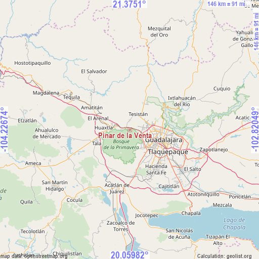
Pinar de la Venta GPS coordinates[2]
20° 43' 8.004" North, 103° 31' 24.996" West
| Map corner | latitude | longitude |
|---|---|---|
| Upper-left | 21.3751°, | -104.22674° |
| Center: | 20.71889°, | -103.52361° |
| Lower-right: | 20.05982°, | -102.82049° |
| Map W x H: | 146.2×146.2 km | = 90.8×90.8mi |
| max Lat: | 32.7° ⇑28% North |
| Pinar de la Venta: | 20.71889° |
| min Lat: | ⇓72% South 14.53588° |
| min Long | Pinar de la Ven | max Long |
| -117.105° | -103.52361° | -86.73105° |
| W 11.6%⇐ | ⇒88.4% E |
Elevation
Elevation of Pinar de la Venta is 1788 m = 5866 ft, and this is 534.3 m = 1753 ft above average elevation for this country.
| Max E: |
3497 m = 11473 ft | 36.6% |
| Pinar de la Venta | 1788 m 5866 ft | |
| Avg. | 1253.7 m = 4113 ft | |
Min E: |
-1 m = -3 ft | 63.4% |
See also: Mexico elevation on elevation.city.
Geographical zone
Pinar de la Venta is located in North Torrid zone (between Equator and Tropic of Cancer). Distance of this Northern Tropic circle is 302.2 km =187.8 mi to North.| Distance of | km | miles | from Pinar de la Venta |
|---|---|---|---|
| North Pole | 7703.3 | 4786.6 | to North |
| Arctic Circle | 5097.4 | 3167.4 | to North |
| Tropic Cancer | 302.2 | 187.8 | to North |
| Equator | 2303.7 | 1431.5 | to South |


Nearby cities:
15 places around Pinar de la Venta: (largest is in red/bold)
• Campestre las Palomas [Fraccionamiento]
13.3 km =8.3 mi,  34°
34°
• Campo Real
11.3 km =7 mi,  47°
47°
• Colonia Cuisillos (Huaxtla de Orendain)
13.7 km =8.5 mi,  272°
272°
• Huaxtla
14.6 km =9.1 mi,  275°
275°
• La Cuchilla (Extramuros de Tesistán)
9.3 km =5.8 mi,  43°
43°
• La Primavera
4.4 km =2.7 mi, 276°
• La Venta del Astillero
2.5 km =1.6 mi,  294°
294°
• Nextipac
5.4 km =3.4 mi,  359°
359°
• Nuevo México
9.4 km =5.8 mi,  63°
63°
• Puerta del Llano
9.8 km =6.1 mi, 41°
• Rancho Contento
4.8 km =3 mi,  98°
98°
• Santa Cruz del Astillero
12.8 km =8 mi, 283°
• Tesistán
10.7 km =6.6 mi, 31°
• Zapopan
14.4 km =8.9 mi,  87°
87°
• Zapopan2
12.9 km =8 mi, 91°
Sources, notices
• [Note1] Compared only with cities in Mexico existing in our database
• [Src1] Map data: © OpenStreetMap contributors (CC-BY-SA)
• [Src2] Other city data from geonames.org with taken over terms of usage.
• [Src3] Geographical zone / Annual Mean Temperature by Robert A. Rohde @ Wikipedia
