Zapopan geodata
Zapopan (Jalisco) is a seat of a second-order administrative division; located in Mexico in America/Mexico_City (GMT-6) time zone. With population of 1,142,483 people, there are 9 cities with bigger population in this country. Compared to other cities in Mexico, 72.1% of cities are located further ↓South; 87.7% of cities are located further →East and 54.3% of cities have lower elevation than Zapopan. Note1


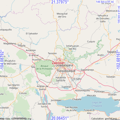
Zapopan GPS coordinates[2]
20° 43' 24.816" North, 103° 23' 5.244" West
| Map corner | latitude | longitude |
|---|---|---|
| Upper-left | 21.37975°, | -104.08792° |
| Center: | 20.72356°, | -103.38479° |
| Lower-right: | 20.06451°, | -102.68167° |
| Map W x H: | 146.2×146.2 km | = 90.8×90.8mi |
| max Lat: | 32.7° ⇑27.9% North |
| Zapopan: | 20.72356° |
| min Lat: | ⇓72.1% South 14.53588° |
| min Long | Zapopan | max Long |
| -117.105° | -103.38479° | -86.73105° |
| W 12.3%⇐ | ⇒87.7% E |
Elevation
Elevation of Zapopan is 1568 m = 5144 ft, and this is 314.3 m = 1031 ft above average elevation for this country.
| Max E: |
3497 m = 11473 ft | 45.7% |
| Zapopan | 1568 m 5144 ft | |
| Avg. | 1253.7 m = 4113 ft | |
Min E: |
-1 m = -3 ft | 54.3% |
See also: Zapopan elevation on elevation.city.
Geographical zone
Zapopan is located in North Torrid zone (between Equator and Tropic of Cancer). Distance of this Northern Tropic circle is 301.7 km =187.5 mi to North.| Distance of | km | miles | from Zapopan |
|---|---|---|---|
| North Pole | 7702.8 | 4786.3 | to North |
| Arctic Circle | 5096.9 | 3167.1 | to North |
| Tropic Cancer | 301.7 | 187.5 | to North |
| Equator | 2304.2 | 1431.8 | to South |


Nearby cities:
15 places around Zapopan: (largest is in red/bold)
• Campestre las Palomas [Fraccionamiento]
12.6 km =7.8 mi,  326°
326°
• Campo Real
9.3 km =5.8 mi,  319°
319°
• Guadalajara
6.4 km =4 mi,  186°
186°
• La Cuchilla (Extramuros de Tesistán)
10.2 km =6.3 mi,  307°
307°
• Mascuala
12.2 km =7.6 mi,  65°
65°
• Nuevo Israel
12.6 km =7.8 mi,  102°
102°
• Nuevo México
7.1 km =4.4 mi,  301°
301°
• Pinar de la Venta
14.4 km =8.9 mi,  267°
267°
• Puerta del Llano
10.5 km =6.5 mi, 310°
• Rancho Contento
9.7 km =6 mi,  262°
262°
• San Esteban (San Miguel Tateposco)
8.4 km =5.2 mi,  7°
7°
• San Isidro
8.3 km =5.2 mi,  24°
24°
• Tesistán
12.3 km =7.6 mi, 314°
• Tlaquepaque
13.2 km =8.2 mi,  133°
133°
• Zapopan2
1.8 km =1.1 mi,  244°
244°
Sources, notices
• [Note1] Compared only with cities in Mexico existing in our database
• [Src1] Map data: © OpenStreetMap contributors (CC-BY-SA)
• [Src2] Other city data from geonames.org with taken over terms of usage.
• [Src3] Geographical zone / Annual Mean Temperature by Robert A. Rohde @ Wikipedia
